• Welcome to the Two Wheeled Texans community! Feel free to hang out and lurk as long as you like. However, we would like to encourage you to register so that you can join the community and use the numerous features on the site. After registering, don't forget to post up an introduction!

The people and the trees were the highlights. A 51 day ride west.

Joined
Oct 16, 2008
Messages
3,798
Reaction score
4,899
Location
Bryan, TX
First Name
Dennie
Last Name
Spears
Maurice did the Tour of Texas last year by zipping around on the last few weekends for quite a few 500 mile days. This year he decided to get started earlier by doing multiple stops while escorting me out of Texas on my ride west. He told all who asked, and some that didn't ask, that he was under judges orders to escort me to the Texas border and make sure I didn't turn around after crossing it. We zigzaged to Amarillo for a total of 840 miles before Maurice thought he had gotten me out of Texas.

We left from my local donut shop where I hang out with other old people. It was 10:00 AM. Maurice is riding a Gold Wing and I am on a DRZ400SM with 8,193 miles on the odometer. It's my fifth DRZ. Attention: Look how clean my rear wheel is.
IMG_20220405_084323995_HDR.jpg


His first stop was going to be Dublin and when I realized we were going to go close to Cranfills gap, I took over the lead. I figure we could stop at the Rock Church and visit my wife's relatives. I have been there many times and thought the gray stone behind Linda's Great Grandparents headstone was a misplaced headstone. Maurice pointed out it was most likely one of the legs for the bench at their feet. I should be able to do something about repairing that bench.
IMG_20220405_123947784.jpg


We rode the short distance into Cranfills Gap and found a closed Horny Toad cafe. It amazes me that Maurice can camp for 2 weeks off of a VFR-800 with no hard luggage and has to use the rear seat of his Gold Wing on a 3 day ride using motels.
IMG_20220405_130531797_HDR.jpg


Along the way, we stopped for the Dublin bottling company and for some reason my pictures don't appear on my camera or my phone. The ToT stop in Abilene was a museum and it was open and I have pictures.
IMG_20220405_163535531.jpg


IMG_20220405_164136511_HDR.jpg


I don't like riding my DRZ on freeways, so we took the back way to his next stop in Post, Texas. This peanut patty was in the convenience store where we stopped for gas. I have never seen a candy bar shaped like another state, nor have I ever seen a waffle iron shaped like any state other than Texas. WE PROUD.
IMG_20220405_184827924.jpg


Next up, the welcome sign in Post, Texas.
IMG_20220405_200859127_HDR.jpg


We spent the night in Saton, TX.
Between the towns of Lubbock and Slaton (home of the world famous Slaton bakery) is a steel house that one man worked on for 29 years before he died. He lived in a finished part of the house for about 6 months. It's on the ToT and was our first stop of day two.
IMG_20220406_090833589.jpg


The steel house is unfinished and not lived in. This man, a friend of the original builder and who may be as eccentric as the builder, would like to change that, but the family refuses to sell.
IMG_5350.JPG


His name is Stance. We were riding down a back road to Lubbock when we saw his Christmas present from his wife. The perfect gift according to him, two gutted VW busses that he is "customizing" when he gets the opportunity. He's the source of my steel house history.
IMG_5354.JPG


What I saw first and what caused me to do a U-turn was his sign.
IMG_5355.JPG


He sells old motorcycle parts and has literally hundreds of thousands of them listed on E-bay. He has a huge warehouse that needs to be bigger and has unusual as well as the usual motorcycle parts. I don't know if he has a clutch for a 1961 NSU, but he may have and I know where he can sell one. Explained later. He also has helmets.
IMG_5351.JPG


We stopped in Happy, Texas. I'm not sure why. Maybe the water tower is on the ToT list. If I had known how many branch banks I would see for the Happy, Texas State Bank, I would have taken pictures of all. The little bank has 36 branches and assets worth $6.8 billion.
IMG_5356.JPG


I'm not sure how many of these next stops are on the ToT, but we rode nearly 400 miles getting from Slaton to Amarillo. We did stop at Motorcycle Gear in Littlefield and it was on the ToT. It was formerly New Enough and is impressive, especially for the small town of Littlefield. No pic.

A ride through Palo Dura Canyon was next. It's one of those places that have to be hiked or biked to be seen properly.
IMG_5357.JPG


Maurice giving me the "evil eye" before we head off to see more of his crap.
IMG_5358.JPG


Amarillo Combine Ranch-it seems everyone is getting on the band wagon.
IMG_5364.JPG


IMG_5362.JPG


The VW Bug Ranch
IMG_20220406_180134649_HDR.jpg


This cross wasn't on Maurice's list. I know this because I stopped and he did not. He said the 100 yards or more of deep grass was too much for his Gold Wing. It wasn't for my DRZ. The cross is biiiiggg.
IMG_5371.JPG


I found Maurice only because I knew his next stop was supposed to be a leaning water tower. It was scheduled for demolition at its original location and was purchased by Ralph Britten. He moved it to its present location and installed it at a lean angle to advertise his truck stop/tourist center. According to locals, it worked until his business burned down.
IMG_5372.JPG


On to White Deer, Texas where they advertise the name of their town in the middle of the main intersection.
IMG_20220406_191032556.jpg


Arising early the next morning, it became clear that we had been away from our wives for way too long.
IMG_20220407_085951561.jpg


IMG_5378.JPG


It was 40* this morning and about 40 MPH winds. Our riding gear felt good as we continued to the Cadillac Ranch and our parting.
IMG_5383.JPG


The ranch comes complete with a food truck that coincidentally sells spray paint as well as souvenirs.
IMG_20220407_094935080.jpg


I guess the biggest sheriff in Texas was not on the ToT list while something in Hobbs, New Mexico was on the list. I offered to ride to Hobbs with him, but Maurice wanted to make it back home without spending another day away from his wife. Those legs really affected him.
IMG_5391.JPG


Maybe the panhandle of Texas is a little too close to Colorado to resist legal sales🚬🚬🚬 because we saw a lot of strange things around Lubbock and Amarillo.

I stopped for lunch in Clayton, NM and found these Stradivarius violins on display.
IMG_5392.JPG


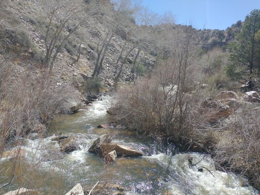
If you have ever been to the Philmont Boy Scout Ranch, you've probably seen these cliffs along a beautiful creek.
IMG_5395.JPG


Eagle Nest Lake was still partially frozen over.
IMG_5398.JPG


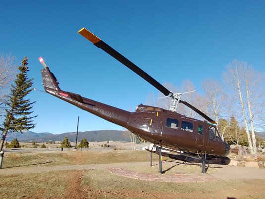
I stopped at the Viet Nam Veterans Memorial to visit with my brother. He has a brick there.
IMG_5399.JPG


My first significant snow and an indication that I may have started my ride a little early. By turning off my headlight, the DRZ's charging system is able to maintain a battery charge while also running my electric jacket liner.
IMG_20220407_183238452_HDR.jpg


I got to my brother's house in Taos, NM before sundown and with enough time to remove the sprocket to see where my leak was. It was definitely the O-ring, but I planned on changing the seal and the O-ring. Today's ride was only about 350 miles.
IMG_20220408_105354180.jpg


IMG_20220408_105359129.jpg


I took my brother and sister in law out to dinner.
IMG_20220408_185848094.jpg


Dessert was green chili chimichangas. Mary and I shared one and then ordered another.
IMG_20220408_190820880.jpg

End of day 3.
 

Attachments

  • IMG_20220407_181518359.jpg
    IMG_20220407_181518359.jpg
    303.2 KB · Views: 130
Last edited:
Day 4. No seal or O-ring was available at the motorcycle shops, auto part stores or ATV stores in Taos. The best any of them could do was a five day wait. I found the seal at a bearing supply in Albuquerque and my brother, Bobby, took me there with the hopes they would also have a matching O-ring. They sold me an O-ring that was the right outer diameter, but was too fat and a seal that was right except it was 1mm thicker than the original. I knew the seal would work, but worried about the O-ring. When we got back to Taos, Bobby had one in his shop that was nearly an exact match. Both worked for the duration of the trip. Zero miles today. I had another zero day in Yosemite when I went hiking and two very low mileage days. One low mileage day was when I changed tires and took my nephew out to dinner. Another low mileage day was changing my battery day which will be explained later. A former motorcycle mechanic should not take nearly a day to change a battery.
 
Last edited:
Always nice to see your adventures :coffee:
 
Day 5 and 6. I took the High Road to Taos, but I was going to Albuquerque. Two nieces, their husbands, their children and their foster children awaited. Few family pics because of foster children protection.

I've passed this grave before, but decided it needed to be revisited. He and his family are passionate about motorcycles.
IMG_5407.JPG


The High Road must be lower than other roads because this is as close as I got to snow.
IMG_20220409_101651118_HDR.jpg


I stopped when I crossed the Santa Cruz River. It was time for a lunch snack and I was in search of waterfalls and bridges.
IMG_5418.JPG


This young boy assured me there was a waterfall downstream. His father wasn't so sure. The boy also liked my motorcycle, but when I suggested a trade for his puppy, the puppy was immediately picked up.
IMG_5410.JPG


I decided to take the kid's advice and walk downstream to his waterfall. About a mile downstream the trail vanished, just after I nearly soiled my pants when the previously unseen duck sitting on these eggs attacked my leg then flew across the river. No waterfall.
IMG_5415.JPG


The song might say, "the road is long," but it's also close.
IMG_5422.JPG


I'm fairly certain there is a waterfall at Nambe Falls. I've never stopped before because it's an artificial waterfall created by a dam. I expected a spillway.

The trail to the falls.
IMG_20220409_151148326_HDR.jpg


I'm not sure living downstream from this lake is the safest place to live.
IMG_5427.JPG


After a short but strenuous hike, I was rewarded with this spillway.
IMG_20220409_152347098_HDR.jpg


My goal for today was to hike Tent Rocks National Monument, but the Cochiti Indian Reservation was closed to non members. I took this picture over a barbed wire fence and was asked to quit taking pictures. The two domes are ovens used for baking bread and cookies. A fire is built in the oven and when the floor and walls are sufficiently heated, the fire is removed and the bread is baked by the residual heat in the adobe.
IMG_20220410_102557688.jpg


I wanted to ride Sandia Peak and the best way to do that was to go down this dirt road to a pay campground.
IMG_5438.JPG


The first use of my new tent. The bungees holding the poles together on my good two person tent have stretched and I didn't test them until a couple of days before my trip began. My choice was either a cheap new tent or a one man tent. I bought.
IMG_5439.JPG


Overlooking Albuquerque
IMG_20220410_143956891_HDR.jpg


One of my nieces is installing artificial turf. I didn't ask why, but nobody in her neighborhood has a lawn.
IMG_20220410_155501978.jpg


No pics at all of dinner or my family. Every shot I took had at least one foster child.
 

Attachments

  • IMG_20220409_130318212.jpg
    IMG_20220409_130318212.jpg
    773.2 KB · Views: 117
Last edited:
My camp last night was in the Turquoise Campground close to the Sandia ski area. It got cold and this morning the wind started blowing right after I finished rolling up my tent. I tried cooking breakfast, but I couldn't find my lighter. It showed up packed in the stove bag. I found it minutes after I bought a replacement.

I took a dirt road from the road up to Sandia Peak to Las Placitas.
IMG_5449.JPG


Bandelier NM is about ready made housing
IMG_5450.JPG


The houses are between 1.1 and 1.4 million years old. That's when the Valles Caldera erupted and deposited Tuff up to 1000' thick during its eruptions.
IMG_5453.JPG


Inside one of the homes
IMG_5454.JPG


I found a pottery shard. The pattern matches some of the pottery examples in the visitor center.
IMG_5456.JPG


I don't remember posing for this statue, but that's definitely me.:giveup::giveup::giveup:
IMG_5466.JPG


I spent the night in Bandelier and cooked oatmeal with my found lighter. In an earlier post, I said I utilized my ratchet/axle nut wrench/tire tool by furthering its use as a spoon. In reality, I forgot my spoon in Bryan and had to buy one at a local Dollar Tree.
IMG_5467.JPG


A very unusual and sacred place, a cave kiva.
IMG_20220412_101907027_HDR.jpg


Some dwellings were multi roomed.
IMG_5483.JPG


As the population grew, they expanded into the valley. Probably homes built by D.R. Horton around the central kiva.
IMG_5482.JPG


I went into Los Alamos for gas and thought I would check on gun restrictions I had mentioned in a post several months ago. Iddave questioned me.
"
. I like hwy 4, but usually have to bypass Los Alamos because of the gun restrictions.
What kind of restrictions are you referring to?"
This is a sign as one approaches any of the entrance to Los Alamos.
IMG_20220413_090500213.jpg


At the guard shack leading into Los Alamos, I asked the E-4 army guy if guns were allowed. The lieutenant sitting at a desk immediately jumped up and asked if I had any firearms. I explained my conversation with iddave and was told the sign had been changed to say, "No Weapons allowed." He pointed at the sign just below the guard shack window. I asked if I could take a picture of the sign and was told that they would immediately determine if I had weapons if I took a picture of the sign. iddave, your right to carry and your right to refuse a search of you or your vehicle are relinquished as soon as you pass the guard shack entering Los Alamos. Los Alamos is essentially a military base.


Day 7
It froze last night. The camp host said it was 15* when he came outside this morning. Water bottles are frozen solid but milk only has ice crystals.

The Caldera that erupted 1.1 million years ago
IMG_20220413_092012447.jpg


I had been advised that 126 was a good, scenic road to get to highway 550 and I took that advise. Amanda's Country Store is on the corner of Highway 4 and 126. She has a pay phone.
IMG_5496.JPG


Amanda said 126 was open and dry and that I would not have any problem on my motorcycle. She was unaware of the recent snow up high.
My first indication of a problem.
IMG_5497.JPG


My bike took 2 naps. My brake and clutch levers match.
IMG_20220413_110328725.jpg


I got a grin approaching Cuba.
IMG_5503.JPG


Lunch in Cuba was a green chili open face hamburger. My first time. If I'm ever in Cuba again, I'll have it again.
IMG_20220413_123214615.jpg
 
It's been years since I've gone to Los Alamos. Things were different then. They had a museum of nuclear stuff that was set up with lots of interactive displays for kids. Neat place. Guess they had to change with the times.
 
I have never seen a candy bar shaped like another state, nor have I ever seen a waffle iron shaped like any state other than Texas. WE PROUD.
That's because no one would recognize any other state besides some of the people who live there. People all around the world recognize the shape of Texas! Yes we are proud!!! Awesome pics and stories!
 
Last edited:
Day 10
I made it to Grants, NM yesterday. It's close to El Malpais which roughly translates to Badland. The main draw is Lava tubes where the outer portion of the flowing lava cooled, but the inner part stayed liquid and flowed out until a hollow tube was left.

Lava fields
IMG_20220414_102414225.jpg


There is a lone arch
IMG_5513.JPG


IMG_5515.JPG


I talked to a ranger in the visitor center and told him I wanted to ride the BDR on the southern end of the park and he was confident that the road would be ok. Some roads in New Mexico are impassable when wet. I enjoyed the 35 mile desolate road while seeing a single vehicle and two backpackers, but......
IMG_5519.JPG


IMG_5527.JPG


IMG_5528.JPG


I was feeling funny so I got a motel, took a hot shower and went to bed with the thermostat turned up way too high. I couldn't get warm so I went to Walmart and bought a blanket to add to the motel covers. Some time during the night I woke up drenched in sweat. Another shower, dry side of the bed and in the morning I woke up feeling fine.
 
Last edited:
Day 11
I stopped for gas before leaving Grants and met a man from Mexico driving a '66 Mustang on Route 66 for his 66th birthday.
IMG_5521.JPG


He had two sons and a grandson going along for the ride and driving a chase vehicle and trailer seen in the background of the pic above.
IMG_5523.JPG


More day 11 later. Donuts are calling me.
 
Day 11 continued
I also met two Jewish students at the same station on a trip from NYC to LA to spend Passover with their families. It was their first trip on a motorcycle.
IMG_5524.JPG


IMG_5525.JPG


The bikes aren't as different as my DRZ and Maurices Gold Wing, but they are definitely not in the same category.
IMG_5526.JPG


I went south on 117 and 36 to Quemado. Side note: There is also a Quemado, Tx. Quemado, NM must have the worlds smallest bank.
IMG_5533.JPG


And a giant metal bull in the parking lot.
IMG_5531.JPG


In Quemada, I met Tony Otero who told me I should ride highways 32 and 180 on my way to highway 191 in Arizona. Since I had ridden 191 several times recently, I took him up on his suggestion. Lots of sweepers.
IMG_20220415_122304506_HDR.jpg


Some of this
IMG_20220415_134905032.jpg


In Reserve, NM they have a statue of Elfago, Baca standing in the remnants of a cabin he holed up in when an estimated 150 cowboys/Texans/outlaws tried to lynch him. Several movies have been made about him and truth is mixed up with fiction. Anyway, he must have been an interesting character. Some say he even bought a badge and appointed himself sheriff.
IMG_5539.JPG
 
Last edited:
In Quemada, I met Tony Otero who told me I should ride highways 32 and 180 on my way to highway 190 in Arizona. Since I had ridden 191 several times recently, I took him up on his suggestion. Lots of sweepers.
A very good suggestion indeed. Just don't do it around dusk or after; mega elk in that area.


In Reserve, NM they have a statue of Elfago, Baca standing in the remnants of a cabin he holed up in when an estimated 150 cowboys/Texans/outlaws tried to lynch him. Several movies have been made about him and truth is mixed up with fiction. Anyway, he must have been an interesting character. Some say he even bought a badge and appointed himself sheriff.
IMG_5539.JPG


This was a Tour Of Honor site in 2017.
Baca 1.jpg


baca 2.jpg
 
Great repot Dennie. I have never been but your picture of the sign reminded me of the Ragtown Gospel Theater. I have not been but was told by ones that have gone, "it is excellent and a fun time. I think a lot of people visit it in the small town of Post.

1654025866504.png
 
Last edited:
Still day 11
When I got to Hwy 78 I turned west to 191 and the fun starts here.
IMG_5556.JPG


IMG_5558.JPG


Barrel cacti about 4' tall and a close up of its flowers.
IMG_20220415_150330390_HDR.jpg


IMG_5565.JPG


I camped south of Safford, Arizona. While Google maps shows a nice motorcycle road, it doesn't show pavement deterioration. On the way south, I saw a motorcycle headed north with a bicycle mounted upright behind the bike the front tire was mounted beside the bicycle. I wanted a picture, but a DRZ400 can't catch many other bikes on straight roads like 191 south of Safford.

Campsite was pretty.
IMG_5568.JPG


Day 12 and 13
I headed to Chiricahua NM with a detour to Fort Bowie National Historic Site
This ranch, at the start of the road to Fort Bowie, had a sign at the entrance.
IMG_5573.JPG


They were conserving this dozer so I jumped across a cattle guard and took a picture. When I turned around, I saw the no trespassing sign. Nobody was around, but when I came out of Fort Bowie there was an elderly man working close to the cattle guard. I stopped and apologized for my trespass and he said, "No problem, I put the sign up to cut down on the number of cars I had to pull out of deep sand."
IMG_5576.JPG


Ft. Apache was built to protect Europeans traveling through Apache Pass. It was a favorite route because of guaranteed water in a nearby spring. Unfortunately, Cochise also wanted the water. A white child was kidnapped, Cochise was falsely accused and arrested, he escaped in a Cut the Tent situation, both sides captured hostages and then executed them. Twenty years of war ensued. Indians lost.
IMG_5594.JPG


Essentially what hundreds lost their lives for, Apache Spring.
IMG_5620.JPG


Including babies and a Medal of Honor recipient.
IMG_5602.JPG


IMG_5603.JPG


What an Apache Teepee actually looked like, or at least similar to this.
IMG_5614.JPG


What an actual ammo bunker looked like.
IMG_5627.JPG


The commanding officer sounds like a reasonable person. The people back east that authorized this building sound like the same ones we now have.
IMG_5631.JPG


The ranger said this could be an actual canon from the fort, but it was for sure one from that period.
IMG_5640.JPG


Early "telegraph" using sunlight, a mirror and an aiming device. It was called a heliograph and sent morse code by light.
IMG_20220416_130918676_HDR.jpg


I include this picture because I just found out that oxen were shod.
IMG_20220416_131036971.jpg


This bust of Cochise was sculpted by using pictures of his son since there are no known pictures of Cochise.
IMG_20220416_131106367_HDR.jpg


This "catclaw" grows on a bushy plant. As a child around 6 years old, I ran into one of those bushes while playing hide and seek. I would still be in that bush if it were not for the help of my two older brothers. Other cacti have similar thorns.
IMG_5641.JPG


On to Chiricahua NM where I was too late to get a campsite. I camped outside the NM in a free site. In my old age, I sure do like paying for the privilege of using a table.
IMG_5658.JPG


The Apaches called Chiricahua "the Land of the Standing Rocks." I wonder why?
IMG_5649.JPG


How much longer?
IMG_5673.JPG


Kissing Rocks
IMG_20220417_103544843_HDR.jpg


From up high.
IMG_5684.JPG


Pinnacle Balanced Rock.
IMG_5690.JPG


Chiricahua is one of those little known monuments. I highly recommend that you go there if you are willing to hike 8 to 16 miles. I hiked 16 miles in two days.
 
Last edited:
Great repot Dennie. I have never been but your picture of the sign reminded me of the Ragtown Gospel Theater. I have not been but was told by ones that have gone, "it is excellent and a fun time. I think a lot of people visit it in the small town of Post.


Thanks
 
Day 14 was a motel day. I needed to wash clothes. My grape stomp method using the bathtub while showering did not work because the motel had a shower only.

I had the same problem on a previous trip. Maybe that bolt is one that should be checked periodically.
IMG_5696.JPG


Another person has too much time on their hands. I guess they don't own a motorcycle to occupy their time.
IMG_5692.JPG


IMG_5695.JPG


I rode back east to Rodeo, NM along this road, road 42. It got a little rough close to the pass, but most standard street bikes could handle it.
IMG_5700.JPG


More "art."
IMG_5701.JPG


IMG_5702.JPG


I ate a late lunch off of a food truck. It's called a Mexican hotdog and has beans, salsa, mayo and mustard. No cheese though. GOOD and I'm not a hotdog fan.
IMG_20220418_130115930.jpg


A copper mine near Bisbee. Much smaller than the one near Morenci, but still impressive.
IMG_5704.JPG


Ocatillo blossom, a sure sign of recent spring rains.
IMG_5707.JPG


I believe this is a black plumbing clean-out plug litter next to a young barrel cactus.
IMG_5709.JPG


It's been two weeks, time for a proof of life photo for my Honey. I'm wearing a freshly washed wet T-shirt and dry shorts, the only clean Item of clothes that I had left.
IMG_20220419_070235405.jpg


Motel time sometimes means oil change time.
IMG_20220419_071847921.jpg


I head to Saguaro National Park next for day 15.
 
Day 15
Before I get into day 15, I want to back up to my Mexican hot dog on a park bench. In 2020, I was on an extended ride and I was mistaken for a homeless man. I returned the favor on day 14 of this trip. There were two large tables in the park where I bought a hot dog and one was in the sun and the other shaded. I have Lupus and try to avoid the sunlight as much as possible. The shaded table was occupied by a man of indeterminant age. He may have been 50 or he may have been 80 or somewhere in between. His clothing had not been washed in a long time. As I approached the table he was sitting at, I said, "Do you mind if I join you?" Silence. I sat down at the other end of the large table, about 9 or 10 feet away. I could get a whiff of his odor every once in a while, and I made the assumption that he was homeless. Before I started eating, I asked him if I could buy him a hot dog. Again, silence. I thought maybe there was a language barrier since we were so close to the border and the Spanish language was so prevalent there. I had eaten about half of my hot dog when he spoke up and said, "I have already had one hot dog, but I'm waiting for the line to get shorter before I get another." We talked for about ten minutes, and it became apparent that he was educated, well traveled and definitely not poor. He gave me suggestions on things to see in California and I took some of his advice. There's a saying, "Not all who wander are lost." I like to say that I don't get lost because I usually don't care where I am. I think my lunch buddy wasn't homeless because he didn't care where he spent the night.

A park ranger at Saguaro NP pointed out that this Hanging Fruit Cholla was much more likely to be a problem than others such as our common Cholla.
IMG_5713.JPG


Saguaro Cactus
IMG_20220419_114215178_HDR.jpg


No need for an AR-15 to protect this home.
IMG_5725.JPG


IMG_20220419_130237966_HDR.jpg


I'm not trying to belittle Saguaro NP because it is special, but for both number and size, it doesn't beat Old Mt. Lemmon Road which starts at the end of pavement on N. General Hitchcock Highway. I suggest you ride General Hitchcock.
IMG_20220419_184053793_HDR.jpg


General Hitchcock Highway
IMG_20220419_161442630.jpg


What one has to endure to get to the "good" saguaro
IMG_5761.JPG


I ate breakfast next door to this motel. Every room had a carport. A sign on the chain link fence at the rear said, "Do Not Back Into Garage."
IMG_5763.JPG
 
Still day 11
When I got to Hwy 78 I turned west to 191 and the fun starts here.
IMG_5556.JPG


A short video starting at this location. 2-up on the Wing. I don't know why I didn't keep the footage from the portion that is closer to 191 as that is much more technical.

 
I ate a late lunch off of a food truck. It's called a Mexican hotdog and has beans, salsa, mayo and mustard. No cheese though. GOOD and I'm not a hotdog fan.
IMG_20220418_130115930.jpg


A copper mine near Bisbee. Much smaller than the one near Morenci, but still impressive.
IMG_5704.JPG
Out here that dog is usually referred to as a Sonoran hot dog. Although I'm a AZ native I've never had one. https://en.wikipedia.org/wiki/Sonoran_hot_dog

The mine is called the Lavender Pit. When the mine shut down, so did Bisbee and it pretty much became a ghost town. Homes were selling for under $1,000. Eventually some free spirits began to purchase property in town and start an Arts & Crafts revival. These days it a very booming place and popular for folks to come and spend the weekend. Bisbee has one of the best climates in the country and I highly recommend one of the walking Ghost Tours.
 
Great report. I love that area around Angel Fire and Red River. And Chiricahua is definitely a place to see. The time I was there it snowed (late March), and we hiked through all of the snow-capped columns. Marvelous!
 
Day 16
Today was going to be a ride called Apache loop in some article I once read in Motorcycle Touring magazine. It consists of highway 60 and the paved/dirt road 188 and connecting roads.

IMG_5764.JPG


This bridge was built to replace the road over the dam at Theodore Roosevelt Lake when the original dam, made of masonry and rubble, was raised 77' and entirely encased in concrete. The renovation took the dam off of the national registry of historic places.
IMG_5766.JPG


Off I went instead to The Grand Canyon, which wasn't on my original plans. First stop along the way was Tonto Bridge. I don't know what a travertine bridge is, but this is believed to be the world's largest. It's 400' long with a 150' opening. Both taken from about the same place. Looking left
IMG_5776.JPG


Looking right. The people in the picture should give a sense of how big the bridge is.
IMG_5781.JPG


IMG_20220420_145654071_HDR.jpg


The road is curvy and steep.
IMG_20220420_154542182_HDR.jpg


I fooled around a little today and only rode about 150 miles. I talked to my wife several times and tried to order tires for when I get to Reno, NV. Johnny at Reno Cycles quoted $808 mounted and balanced. My wife found them on the internet for $365 shipped but unmounted and balanced. My labor would save $433 so she ordered them.

Day 17
I made it to the line waiting to get into the Grand Canyon. It was long and a flashing road sign said the wait was over two hours. I had suspected as much because highway 89 was completely closed to the second main entrance to the south rim. Even people going north, but not to the GC, were routed through the only southern entrance. I waited 15 minutes and nobody in the line moved. I U-turned.

Sculptures at a convenience store/souvenir shop on Hwy 64 just south of the park.
IMG_5782.JPG


IMG_5784.JPG


The local motel did several a little classier.
IMG_5785.JPG


Day 17 continues when I return from taking my wife to see Top Gun.
 
Last edited:
Back
Top