• Welcome to the Two Wheeled Texans community! Feel free to hang out and lurk as long as you like. However, we would like to encourage you to register so that you can join the community and use the numerous features on the site. After registering, don't forget to post up an introduction!

A Summer Long Ride

Up on top...

day9-30.jpg

Just off the tram, I ungracefully maneuvered my way over some slick dirty snow and snapped this first photo.

day9-31.jpg

A ten minute walk upwards brought me to this lovely vantage point.

day9-32.jpg

Both surprised and delighted by lots of fresh snow...

day9-33.jpg
A little further up, the view gets even better. Again, I am wondering how such a beautiful place is not on more people's radar.

day9-34.jpg

Looking northeast at the Bitterroot mountains. Somewhere in there is Lolo pass which the half-starved Lewis and Clark expedition stumbled out of on their way to the Columbia river.

Her name was Watkuweis

She was an elderly Nez Perce woman who was present when the starving Lewis and Clark expedition stumbled down the backside of the Bitteroot mountains into the hands of her tribe. The entire expedition was nearly dead. Sick. Hungry. Weak. Desperate. The Nez Perce had never seen white men before and the younger braves wanted to kill them all. After all, the Corps were traveling with the latest in weaponry, plus caches of bullets, boxes of trading goods and other riches. A hostile takeover of the Corps’ goods would make the Nez Perce rich beyond measure.

But that’s when Watkuweis spoke up and stopped her own warriors from killing the Lewis and Clark party. Her words were simple: “Do them no harm.” Why would Watkuweis care so much for a starving group of white explorers? It’s because she knew their generosity and compassion well. Like Sacagawea, she had also been captured as a youth, abused and traded among Indian tribes in Canada.

Eventually Watkuweis was purchased by a kind white fur trader who took her far away to the Great Lakes region. She was raised in a white community, learning white customs, manners and their Christianity. A white (Christian) family eventually helped her escape slavery and return to her Nez Perce home in the Rockies. Consequently, all her life, Watkuweis held a deep affection and gratitude for white people. For Lewis and Clark’s Corps of Discovery, this old Indian woman was their saving angel.

They would remain with the expedition in one way or another until 25 October 1805 where they said goodbye at Fort Rock at The Dalles. They would join once again on 23 April 1806 meeting a family of travelers at Rock Creek on the Columbia River. Their final day, 4 July 1806, was at present-day Missoula, Montana. The Nez Perce provided the expedition’s longest period of contact with any Native American Nation.

day9-35.jpg

Wow, just wow...

day9-37a.jpg

A few steps later, I stumbled across these two lovers and just had to get a photo...

day9-37.jpg

Clearly unimpressed with my interruption, I got the message and made my way back to the tram station.

day9-39.jpg

On the way back down...

I took out my phone and filmed the following sequence:


My impression of the Wallowa Valley greatly exceeded all expectations. I will wrap up Day 9 by injecting Chief Joseph's famous and very sad speech here:

Tell General Howard I know his heart. What he told me before, I have it in my heart. I am tired of fighting. Our Chiefs are killed; Looking Glass is dead; Ta Hool Hool Shute is dead. The old men are all dead. It is the young men who say yes or no. He who led the young men [Olikut] is dead. It is cold, and we have no blankets. The little children are freezing to death. My people, some of them, have run away to the hills, and have no blankets, no food. No one knows where they are—perhaps freezing to death. I want to have time to look for my children, and see how many of them I can find. Maybe I shall find them among the dead. Hear me, my Chiefs! I am tired; my heart is sick and sad. From where the sun now stands I will fight no more forever.

AND by suggesting an excellent book I picked up at the Lolo pass ranger station:

yellowwolf.jpg
 

Attachments

  • day9-39.jpg
    day9-39.jpg
    527.9 KB · Views: 128
  • day9-38.jpg
    day9-38.jpg
    474 KB · Views: 140
Day 10 - Joseph, Oregon to Packwood, Washington

Fully rested from an off bike day in Joseph, I was out the door by 8am to continue my ride into the unknown. I did not want to ride the freeway but with the Columbia river, gorge and Mount Hood right next to it, I-84 turned out to be the most scenic route.

map10.png


Even I get photo and video wary and that is how I spent the first half of the day. I really just wanted to make good time to the gorge so I could slow down and enjoy the scenery on the east side of Mount St. Helens.

The road from Joseph to I-84 at LaGrande was gorgeous Oregon looking scenery - mountains, hills, hollows, streams and fields all mixed together. This made for a great start to the day and after about an hour, I reached I-84. The first hour or so on the freeway was spent in the mountains which was rather nice. After that, I encountered the most abrupt and interesting step down I have ever seen:

Google Maps - Dead man's pass Oregon

I am guessing but it had to be close to a thousand foot drop into the northwest desert I have heard so much about. It was an interesting experience to wind back and forth through there. Unfortunately, the desert with its all too common friend - wind, was waiting for me. The temperature also picked up and I started wondering if I had picked the right route. It did not take long for my original decision to be reinforced by the sight of the Columbia river. This was my first time to see it and now understood many things I have read. I also wondered what Lewis and Clark thought as they made their way west in between these barren hills.

Another hour into the ride brought me to the Dalles which is another interesting sight. I don't think I have ever seen a dam oriented in such a way before. The barren hills were starting to give way to more trees and northwest greenness. Mount Hood also stood prominently ahead of me making for quite a sight. Just a few miles down the road, Hood River was where I would exit the freeway and eventually head into the mountains. Before that, it was time for a well deserved lunch at McDonalds. I never understand why I stop there. Childhood subliminal advertising techniques I am sure.

The weather had become rather nice and cool as I crossed the Columbia into Washington and headed west to Carson. The sights along this stretch of road were amazing. The Columbia River Gorge's natural beauty is beyond anything I can adequately describe.

At Carson, I headed north into the mountains.

map10b.png

A triangle of volcanoes...

day10-1.jpg

After missing all that cool scenery, I finally forced myself to get with it. Here are the first two photos of the day.
day10-2.jpg


day10-4.jpg

Quite early on, I realized this was going to be a slower segment than expected. The road has serious issues in some places. I have 110k miles on FJRs and have never been bucked by them like a dirt bike. Therefore, it seemed wise to slow things down some and focus on not falling into the deep ruts and ridges.


day10-6.jpg

It had been close to 90 degrees along most of the Columbia river. Here I was gaining elevation and seeing temps around 50 degrees which is typically when I start using my electric jacket liner.

day10-9.jpg

Strange. I had no idea I had gained enough elevation for snow. Considering the snow line on the mountain peaks, this had to be somewhere between 5000-7000 feet. Besides looking at an altimeter, the tree cover conceals the extent of the ascent.

day10-11.jpg

Just as quick as the snow appeared, it was gone. The trees starting becoming even more dense and dark underneath. I am not accustomed to seeing such darkness in the daytime. It really was an unusual experience.

day10-12.jpg

I was 11 years old when Mount St. Helens erupted. It was incredible site to see on TV and something I will never forget. Since then, I have wanted to see it for myself but never had the opportunity. So, the mere sighting of a sign with those words on it is cause for Stoke level 10.

Even though my visit to Johnston Ridge was coming up the following day, I was very close to the mountain and blast zone.
map10d.png

Forty two years later, the blast zone is still clearly visible from above. The trees are also easily seen still floating in Spirit Lake.

day10-13.jpg

One hundred miles of secluded roads combined with beautiful unfamiliar scenery made for a great afternoon escape.

day10-16.jpg

I was absolutely captivated by the ferns. Every direction I looked in was super cool.

day10-18.jpg

The turnoff to Windy ridge. In hindsight, I wish I had allotted time to see the mountain and Spirit Lake from there but I had my eyes focused on Johnston Ridge. Next time, I suppose.

Here it is with photos on Google maps:

Windy Ridge

day10-20.jpg

More of that dark forest feeling as I thoroughly enjoy the ride.

day10-22.jpg

day10-23.jpg

day10-26.jpg

I remember thinking "if the rough part is ahead, what was that I just rode through".

day10-28.jpg

"Enchanting" is one way to describe this scene.

day10-30.jpg

day10-32.jpg

Not too far outside of Randle: This is the only place I am aware of that my route came close enough to see blast damage. Along the ridge lines directly ahead.

From here it was about a 20 mile ride into Packwood where I would be staying for the night. Along the way I got popped by radar twice. Because of the trees, I never saw them which I thought was sneaky.

The folks in Packwood turned out to be a nice bunch. I was unpacking my bike when a woman staying at my hotel from the UK walked up and started quizzing me about the bike, where I had been, where I was going and so on. It turns out she rides too and was hungry like me. So, I had someone nice to talk to over dinner and that is always nice after a few solo days on the road. :thumb:
 
Last edited:
Day 11 - Packwood, Washington to Reedsport, Oregon

I had four destinations in Oregon for this trip. But, the real reason I rode all the way up there was to see Mount St. Helens. Before May 18, 1980, Johnston Ridge was known as Coldwater Ridge. Anyone that has studied the eruption of Mount Vesuvius should have know this observation point was much to close to the summit.

32818-Mount-St--Helens-from-Coldwater-II-observation-station--USGS-geo.jpg


Dave Johnston drew the short straw when he agreed to work that weekend for someone else that could not be there. He was located five miles from the summit at "Coldwater II" and only had time to yell "Vancouver, Vancouver, this is it" before being blasted off the mountainside. Nothing of him or anything else that was at the site was ever found. The visitors center is now located where Dave is sitting in the photo below.

coldwater2.jpg

Dave Johnston at Coldwater II about 13 hours before the eruption.


Today's route:

map11.jpg


This segment:

map11b.jpg


The ride west on Washington-12 was uneventful except I got zapped by radar again going 60 in a 55. I did not bother to slow down and noticed that the policeman (seen this time) seemed to be acting as if he were trying to decide whether or not to pull me over. Fortunately for me, he kept on going. The only reason why I mention it is because in over 5000 miles of riding, this little area has taken the prize for most police radar and that kind of surprises me.

Anyway, I rode past Rifle Lake and at Morton took the back way into Johnston Ridge. As with the day before, the countryside continued to delight the eyes. I remember thinking that I could be working and how glad I was here and not there - that my co-workers were suckers for not being here with me. Ha!

The ride to Johnston Ridge turned out to be very nice as I crossed the Cowlitz River a few times and finally the Toutle which turned out to be something to see. Through the trees, I caught my first glimpse of Mount St. Helens. At the next pull out, I started rolling gopro video again to capture all the things I never could before with just a camera.

This entire series of images is spent well within the blast perimeter. Some of the video the images come from can be found here -

day11-6.jpg

day11-7.jpg

day11-8.jpg

day11-9.jpg

It was tough to stay on the road and keep my eyes on the mountain but I did it. What an awesome view!

day11-11.jpg

The blast damage is obvious in some places as on the ridges in front of me but this entire area was wiped clean. Weyerhaeuser started planting trees a couple of years after the eruption. In many places outside of the monument, the only way you can tell you are in the blast zone is trees look forty years old instead of one hundred or more.

day11-10.jpg

The Toutle River valley floor with the mud flow remains of Mount St. Helens sitting anywhere from 100-600 feet above the pre-eruption levels.

day11-13.jpg

No hunting, no pets, no camping and no alcohol. With Mount St. Helens in sight all I could think of is these people are no fun at all.

day11-16.jpg

Getting close. Coldwater Creek with Johnston Ridge coming up.

day11-17.jpg

One would think that people would have been protected had they been on this side of Coldwater (now known as Johnston Ridge) Ridge but they were not. The hot gasses swept over the ridge lines like a roller coaster.

day11-18.jpg

Within the monument, everything has been left as is to recover naturally. I rode up to the Johnston Ridge Observatory parking lot and headed on in. This is one of those views you never forget.

day11-19.jpg

day11-20.jpg

day11-21.jpg


day11-22.jpg

You can quite literally see where the mountain sides stop and the landslide fill begins near the top of this photo. Almost everything you see here used to reside on or near the top of the mountain.

day11-24.jpg

Somewhat behind Johnston Ridge one can see large chunks of the mountain that were blasted out six miles.

day11-25.jpg

Many fallen tree trunks are still visible on the side of this ridge.

day11-26.jpg

A different view of the remains of the hot landslide mud that flowed fourteen miles down the Toutle River Valley. On the map below, you can see what used to be on top of Mount St. Helens strung out in the river valley all the way past where it says Eco Park Resort.

Map11c.png


I hung around the observatory for a couple of hours hiking around and enjoying the scenery. It was kind of a strange feeling to be exactly where Dave Johnston was when he got incinerated and/or blown off the ridge. While not likely, That same thing could happen to me. Sudden earth quake and then absolute destruction.

I am not sure why I missed this in the planning stages but only a small sliver of Spirit Lake could be seen from Johnston Ridge. I was really looking forwards to seeing the floating trees and the location where Harry Truman's lodge once stood - now under about two hundred feet of water and mud. What happened there was completely bizarre. As the landslide began and opened up the side of the mountain, the volcano exploded laterally. The gases quickly overtook the landslide and slammed into Spirit lake destroying everything. Right after that, the landslide hit the lake and caused four hundred foot waves to crash high into the mountain sides. This caused the lake to fill back in a couple hundred feet higher than it had just been a minute earlier.

Visiting Mount St. Helens was an exercise in insignificance. It is a clear example of what Voltaire meant when he said "Men argue, Nature acts".

There are a number of decent documentaries on Youtube. I like this one because of all the old TV footage. It also shows a little more of the human side of things without commentary -
 
Last edited:
Got to get all the way to the Bay area before Part II stops. :-D

day11-28.jpg

Try to imagine what it took to do this...

day11-29.jpg

On the way out, I stopped to take a nice photo of this reliable machine.

I had warm sunny skies until I crossed the Columbia River at Longview. I knew I would eventually appreciate carrying around 30lbs of heavy water proof gear and now was the time. The weather became quite gloomy and rainy for the entire ride to Astoria where it dried out some.

day11-30.jpg

Somewhere just south of Astoria.
day11-31.jpg


I may just have bad luck but I am not that keen about riding the pacific coast. As soon as it gets warm inland, the heat sucks the marine layer onshore and ruins the day. There is a view and traffic issue to consider as well.

The first 125 miles was everything I had expected it to be. Lots of 30mph zones, lots of tourists and most views of the Pacific Ocean obstructed by trees. I was kicking myself for not intercepting the coast further south. However, I stuck with the route and was eventually rewarded with amazing but intermittent views of the coast line. The canopy was also very very cool in places. For anyone taking notes, the coast line from Newport to Reedsport is very nice and not congested. I would ride there again and think often about doing that on the way back home.

Today's ultimate goal was to get as far south as I could before dark. I had piddled around for a long time at Mount St. Helens and had some miles to make up. As a result of that, I stopped very few times and left the cameras stored for the rest of the day. I made it to Reedsport before I decided to wave the white flag and look for a place to spend the night. Staying the night in Reedsport set me up perfectly for the next day's destination.
 
Day 12 - Reedsport, Oregon to Klamath Falls, Oregon

Today is another purposely scheduled half day of riding. Visiting Crater Lake National Park has been on my radar screen for a long time.

Today's Route:

Map12.png


I woke up feeling good and ready to ride. I headed inland on Oregon-38 and was immediately greeted with this scenery. The next series of in flight shots sum up the overall Oregon "feeling" for me.

day12-2.jpg

day12-4.jpg

day12-5.jpg

day12-7.jpg

day12-8.jpg

day12-9.jpg

day12-10.jpg

day12-11.jpg
 
Crater Lake National Park

I bought this year's annual national park pass at the TWT "Around the Bend" rally. At $80, I feel compelled to get my moneys worth out of it. So far, this is the breakdown:

1. Big Ben National Park
2. Zion National Park twice
3. Crater Lake National Park
4. I'll ride through Yosemite on the way home
5. Grand Canyon North Rim on the way home
6. Big Bend in October

At $25 per motorcycle, I have already made my money back and seen some very cool things in the process.

The terrain near Crater Lake is mountainous. The average elevation is around 6000 feet. The air is clean and the feeling of truly being out in the middle of nowhere is strong.

day12-19.jpg

I have encountered snow several times on this trip but this is the most I have seen so far.

day12-20.jpg

I have grown to really like those "Cascade" looking peaks. Kind of like the Beartooth mountains but ever so slightly different.

day12-21.jpg

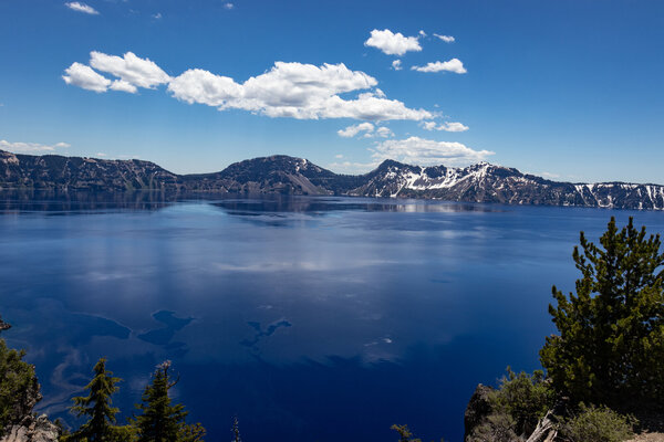
This first view of the lake really got my attention. The blue water looks unlike anything I have ever seen before.

day12-13.jpg

I turned around and took the "Volcanic Legacy Scenic Biway" around the other side of the crater. I cannot describe the way I felt when out here. This site is so unusual and remarkable that it seems to silence most people. All you can really do is gaze upon this amazing sight.

day12-14.jpg

It takes zero effort to get amazing photos here. Even the gopro is doing a better than usual job. I love the reflections!

day12-17.jpg

Cloudcap overlook.

day12-16.jpg

At its deepest point, the lake is 1,943 feet deep. It is literally an upside down mountain.

Switching from gopro to Canon DSLR...

day12-24.jpg

Incredible scenery makes my amateur photos look almost professional.

day12-25.jpg

I was surprised to learn that the eruptions and formation of the crater occurred only 7,700 years ago. This is seriously new.

day12-27.jpg

This location is called the Phantom ship overlook.

day12-29.jpg

Llao rock.

day12-31.jpg

Cloudcap overlook.

day12-32.jpg

Llao Rock

day12-33.jpg

Merriam Point and Wizard Island - a lava dome.

day12-34.jpg

day12-38.jpg

No doubt, this is an alien disguised as a bird. Seriously though, this is a Clark Nutcracker. They eat the seeds out of white bark pine cones.

day12-39.jpg

day12-35.jpg

Union Peak - This looks like a real jewel of a park. I am definitely coming back here to camp and hike.

After spending a couple of hours hanging out a various points around the crater, it was time for lunch and that means National Park hot dogs. In my opinion, they are the safest thing to eat from the cafeterias. They are not too bad either.

Crater Lake National Park left an impression on me. The natural beauty speaks for itself. The park is not congested. The air is clean and cool. It is just a really cool place to see. I highly recommend it.

It took me about an hour and a half to get to Klamath Falls, the destination for the night. It is an interesting ride down the mountains and into the valley near Fort Klamath. The temperature started picking up again. I got to town, found a hotel, had dinner and thought about the incredibly varied scenery I had seen. Very cool indeed!
 

Attachments

  • day12-26.jpg
    day12-26.jpg
    266.4 KB · Views: 119
  • day12-23.jpg
    day12-23.jpg
    288.7 KB · Views: 112
I got stuck in flash floods just at the top going down the east side of 108 Sonora Pass, on a R90/6 back when I was young and fearless. 6 inch rocks bouncing of my wheels while coasting engine off down through 10" of fast moving water. Those were the good ol days when I'm frequently do a 600 mile day ride over the Sierras and back to my home in Mountain View, CA. Our favorite camp spot was at the summit on 108. And there's a hidden lake 3 miles off road on the SE side of the summit with some of the best trout fishing in CA, at least 20 years ago...
 
I got stuck in flash floods just at the top going down the east side of 108 Sonora Pass, on a R90/6 back when I was young and fearless. 6 inch rocks bouncing of my wheels while coasting engine off down through 10" of fast moving water. Those were the good ol days when I'm frequently do a 600 mile day ride over the Sierras and back to my home in Mountain View, CA. Our favorite camp spot was at the summit on 108. And there's a hidden lake 3 miles off road on the SE side of the summit with some of the best trout fishing in CA, at least 20 years ago...
Fun memories. The lake you mention sounds like it is close to Kennedy Meadows. That entire area is absolutely stunning.
 
Day 13 - Klamath Falls, Oregon to Fortuna, California

I was a little apprehensive about leaving Oregon. I really enjoyed it there but it was time to start wrapping this part up. I had two days before I wanted to be in the bay area. That would give me a day to take care of some personal business before flying home.

I jumped on my bike and started the day's ride heading towards the mountains on Oregon-66. Before I did that, I decided to fill up and finally figured out why there were always people hanging around the pumps trying to fill up everyone's tank - why I kept getting nasty looks when I would pump my own. Apparently, there is a law against self service gas stations in Oregon. It seems I could have been fined $500 each time I did that. So please don't turn me in.

Today's route:

Map13.png


After recognizing my evil ways, I decided to go easy and leave town. Oregon-66 was a real nice twisty mountain road with incredible views near I-5. At one point, a large coyote or wolf ran about 100 yards in front of me and kept hauling the mail until out of sight. That was seriously cool.

Of all things, even I-5 was a real nice ride through the mountains into California. However, every time I ride into that state, it is not long before I start wondering where the race is. There seems to be something in the water that makes people drive very fast and come at you from all directions. Practicing avoidance requires some seriously high speeds.

It was a nice cool 100 degrees on I-5 which made taking the first squiggly line to the coast an absolute must. I have ridden CA-96 one time before, but from the other direction so all was good. I was enjoying a spirited ride until I came around a corner and saw CHP jumping out onto the road about a half mile in front of me. I went wide and stayed flustered for a while. I would also spend the next 50 or more miles wondering which corner or shadow he would be waiting for me in.

In order to put a little time in between, I stopped for a break along the river and put the gopro on.

day13-18.jpg

Gotta love $35 fill ups!!!

day13-1.jpg

day13-2.jpg

day13-8.jpg

One of a hand full of bridges that cross the Klamath River.

day13-10.jpg
Other riders out having fun too.
day13-11.jpg

Much further out than I expected, my CHP friend makes a reappearance at a good time.

day13-15.jpg

The rural roads in California are more often than not, quite technical and seemingly never ending.

day13-16.jpg

day13-14.jpg


I made my way to Willow Creek and turned onto CA-299 for the last ~50 miles into Fortuna. There is something about the ridge line right before the Pacific ocean. No matter what part of the coast line I am at, this last ridge always seems very technical with dense tree cover. The cooler marine layer also starts making its presence known. I wound down the mountainside and caught my first glimpse of the Pacific Ocean in a couple of days. The cool wet air felt wonderful after the heat I experienced earlier in the day. It was not too long before I pulled up at my hotel. Since I was on the Pacific, it was time for some shrimp and chips and tasty suds at the Eel River Brewing company which made for a great way to end another wonderful day on the road!

I don't think these videos are that interesting but here it is anyway...


Attachments

  • day13-12.jpg
    day13-12.jpg
    466 KB · Views: 117
  • day13-13.jpg
    day13-13.jpg
    414.7 KB · Views: 122
  • day13-14.jpg
    day13-14.jpg
    595.7 KB · Views: 132
  • day13-15.jpg
    day13-15.jpg
    591.3 KB · Views: 115
  • day13-3.jpg
    day13-3.jpg
    568.4 KB · Views: 117
  • day13-5.jpg
    day13-5.jpg
    459.6 KB · Views: 118
  • day13-6.jpg
    day13-6.jpg
    439.4 KB · Views: 120
  • day13-7.jpg
    day13-7.jpg
    418.4 KB · Views: 146
Day 14 - Fortuna, California to Santa Clara, California

It's the last full day of this part of the ride. I am tired and looking forward to a few down days in my own home. I am not looking forward to hooking back into the machine.

map14.jpg


It has been about ten years since I last rode in this area. I am within easy striking range of the bay area so there really is no hurry at all. Unfortunately, rain has been in the forecast at Fortuna and along the coast for days. I was hoping they were wrong but they were right. On comes the rain gear. I call it that but I am actually talking about Klim Carlsbad Jacket/Pants. Anyway, with a heated jacket liner underneath, I started my ride down 101 comfortably in light rain and 50 degrees.

Just a few miles south of Fortuna, 101 routes directly through a giant redwood grove. Running parallel to it is the Avenue of the Giants. It is something straight out of a fantasy novel. This time with dark skies and light rain, it was seriously wicked looking in there. If you do not know what I am talking about, you need to go see it. A little further down 101, Highway 1 veers towards the coast. As is typical, a ridge line with switchbacks on the ascent and descent must be negotiated before getting to the ocean.

On the coast at Rockport, my fears became realized as the weather was just awful. Rain and fog had set in and that ruins any kind of coastal experience for me. As I have mentioned before, I have been through this a few times before. So, when I get the chance, I will head inland where the sun is sure to be shining. The scenery is different but just as breathtaking.

day14-1.jpg

Catching a little break from the rain in Mendocino, I took my one and only photo of the Pacific Ocean today before starting my way inland on CA-128. As with all the roads that lead to the coast here, CA-128 was wonderful and dry ride through dense redwoods and gorgeous Sonoma countryside. Not too far off the coast, I noticed an old giant hollowed out stump and decided to pull over.

day14-5.jpg

It was kind of spooky down in this area. No bells on my shoes, I kept wondering if a mountain lion was going to get me. They are seriously large up here.

day14-2.jpg

The trees are too tall to capture with a regular lens.

day14-3.jpg

I don't know why I kept thinking about mountain lions but I did. I got back on my bike and rode further inland.


day14-17.jpg

Back on the road and enjoying these magnificent trees.

day14-6.jpg

Sigh... only two hours before I am plunged back into big city traffic and people.

day14-10.jpg

Continuing southeast on CA-128, the towering (and close) redwoods continue to create a seldom experienced sensation.

day14-18.jpg


day14-20.jpg

I keep thinking that hobbits or wizards or something else equally weird was going to jump out in front of me.

day14-21.jpg


day14-24.jpg

The redwood trees eventually give way to the Oak trees and vineyards of Sonoma.

The road continued on for quite some time eventually taking me to 101 south. I endured a little freeway riding until I reached Santa Rosa where I turned back towards the coast. Jenner to Stinson Beach is my favorite stretch of Highway 1, period. Unfortunately, seriously high winds were blowing in over the water which pounded me the entire way. Getting a face full of sea spray up on some of those cliffs is not a good sign. But, I have to admit enjoying the variables that mother nature throws in front of me. Just no ice or lightning please. The wind finally became more reasonable near Point Reyes where the hills on the west side of Tomales bay provide a little block.

day14-35.jpg

A nice weather day in 2015. Inverness on Tomales Bay.

It was still early so I decided I would ride back to the old Nike missile base which I think is a pretty cool place. That plan was quickly cancelled as I rode into the worst glob of tourists I can remember ever seeing at the bridge.

Fortunately, in California with the exception of the occasional psycho, it is no skin off anyone's back if motorcyclists skip the line and park somewhere no car can fit into. Like someone else also recently mentioned, they are just happy we are not in front of them or taking one of the car sized parking places. I found a small sliver to park on and got the gopro ready for the ride into the city.


day14-26.jpg

For some reason, the Golden Gate Bridge has always escaped the gopro, but not this time.

day14-27.jpg

The bridge does not provide the best views along the roadside but people watching is still good. All I ask is for no one to jump off the bridge while I am riding over it.

day14-29.jpg

For many years, the toll was $5. Considering they did not collect a toll going the other direction, it was not too bad. The 2022 price is $10.

day14-31.jpg

No matter what you think of this area, no one can deny that this city is located in one of the prettiest areas in the country.

day14-32.jpg

Although, you may have had a different opinion if viewing it from that island over there.

day14-33.jpg

Angel Island and Alcatraz.

I do not like riding in big cities but I do like riding in San Francisco. The terrain and obstacles make it quite a unique place for a motorcycle. I have this thing for looking for the most precarious hills and curves and taking a shot at them. It gives me something to do on the rare occasions I find myself there. I did that for a while and then started my way south down 101 to Santa Clara. I parked my bike in a friends garage, had a nice dinner and officially closed out Part II. I still had one more day left in the bay area though...


I like Telegraph Hill because of the views. Coit Tower is pretty cool as well. The automated toilet at the entrance worried me a little though. A few off bike shots to close this one out...

day14-40.jpg


day14-37.jpg


day14-38.jpg
 
Last edited:
Day 15 - Santa Cruz Mountains

I had some personal business to take care of in Oakland so I was out early and on my way north. The old Raider football field is still there and reminds me of the good days before stadiums were named after corporations.

I did what I needed to do and then headed towards SF on the new(er) bay bridge where I met my first traffic blockage across all lanes. When I approach stopped traffic in California, my initial thought it dang, I really don't want to do this. But, that feeling soon changes over to hey I don't have to wait in this mess and I am off and going. I have figured out a few things that work for me. I do not lane split above 45mph. I use high rpms and back pressure to do most of my braking. Reaction time to the brake lever/pedal takes too long to use alone. It is one thing to lane split for less than a mile. It is something else entirely to do it for 30 miles straight. In the end, I am kind of glad it is not legal here. I think if I had the option to do it everyday, my luck would eventually run out.

But, I digress. Once in the city, it was just a matter of negotiating a few roads before I was on 101 south again. A short distance past SFO, I decided to take the exit to Half Moon Bay and then onto Skyline. This roads leads to Alice's restaurant and where I used to live.

Map15.png

Skyline runs the ridge between Silicon Valley on the east and the Pacific Ocean on the west. Quite often, the fog from the ocean rushes over the ridges at high speed making for quite a show.

day15-3.jpg

The fog creates enough moisture to make it feel like a rain forest up here. The redwoods are not quite as tall here as further north but just as mystical.
day15-5.jpg

A happy duck out of water I am in these parts. If I were independently wealthy, I would be tempted to live in these mountains again.

day15-10.jpg

But, it does get very cold up here in the Winter. Redwood trees have very poor root structure. A 25mph wind is all it takes to knock them over. This road routinely has downed trees lying across it.

day15-11.jpg

You cannot day dream here the way you can in Texas. The price of failure is very high. One of a hundred trees will get you long before the ground does.

day15-15.jpg

At times, the trees disappear and reveal what is beyond. This is looking towards the Pacific Ocean. Probably somewhere around Pescadero. The beaches from there to Santa Cruz are very nice but you have to be careful when descending the cliffs to get to them. It sure makes carrying ice chests no fun.

day15-16.jpg

Looking the other direction, you can see the South Bay and Silicon Valley.

day15-17.jpg

There are many roads throughout the Santa Cruz mountains. My wife grew up in Boulder Creek and showed me many of them. Most are so technical, speeds above 40mph are difficult to obtain.

day15-18.jpg

On weekends, there are an endless parade of motorcycles and unfortunately emergency vehicles here.

day15-19.jpg

Once you figure out where the curves and switchbacks are, it is a lot of fun. But, CHP is always up here somewhere. Probably just around a corner in the shadows.

day15-20.jpg

These are certainly not the highest mountains, but they are much taller than hills.

day15-21.jpg


Highway 9 was just as puckering fun as it always is. It more or less ends in the town I lived in for a couple of years - Saratoga village. Every time I come back, I want to live here again. But, it does not take long before I remember that in a multitude of ways, California living is just too much...

This was by far the best long distance ride I have made since my first one in 2010. It was good for my soul on many different levels.

Part III was a couple of weeks ago. Part IV is coming up in September.

End of Part II
 
Last edited:
Back
Top