• Welcome to the Two Wheeled Texans community! Feel free to hang out and lurk as long as you like. However, we would like to encourage you to register so that you can join the community and use the numerous features on the site. After registering, don't forget to post up an introduction!

Time Has Come Today

Orange trails are "KTM" trails, you have to ride them. ;)

Looks like a great time so far, love those last shots you posted there.
 
That ledge looks pretty intimidating to a flatland east Tx rider. Good job. How do you find your way around, doesn't seem marked.
 
That ledge looks pretty intimidating to a flatland east Tx rider. Good job. How do you find your way around, doesn't seem marked.
Thanks. They intimidate me too but I just take a deep breath and charge up them. It’s not particularly bright but it has worked so far.

I’m using a Garmin Montana 700. The only real problem is the dust combined with my goggles makes it hard to see sometimes.
 
16E4A63F-6CF9-4B5B-A5B0-829DDCCB91DB.jpeg

Today was the Poison Spring Canyon ride. Here we are at the start just off Utah 95.

We have been watching the Dirty Devil depth and flow gauge for the last several days and mostly wrote off fording it. However, the flow started to show signs of the end of the snow melt, so we decided we would figure it out when we saw it.

It was cool to see where Poison Spring drains into the wash and creates streams of water to ride in almost all the way to the river.

Just outside of Cassidy Camp, we encountered the first of several groups of people in SBS (side by sides) Then we rode up behind a couple of vehicles. The one up front was stuck in the mud.

5A401FED-8300-4BBC-92A2-A830266489DB.jpeg

They were kind of just sitting there with perplexed looks on their faces. That’s Jredford up there taking control and helping to get the job done. The white van had dug 4 equally deep holes and high centered itself in the middle.

Eventually, they were able to pull the stuck van out of the water and mud but not without a little excitement that made us chuckle.

D044F5D0-A129-4792-8A0C-F6813D6C60AE.jpeg


D35A231D-9EA0-4304-9594-BB990A5CA1C3.jpeg

With the white van back on solid ground, I took a couple of photos of the obstacle. I walked out into the water and decided it was a little sketchy, so we found an alternate route that was not too terribly difficult to get through.

F8AFFBFC-3083-4B9E-B7CF-A35AF9B47F5E.jpeg

Once back on our way, it was only a minute before we were at Cassidy camp. Butch and many others used this secluded area to water and feed the livestock he brought through the canyon.
7395D57D-507F-4A82-8221-99FEFDCBD9D5.jpeg


848513A5-87F0-4EB7-B5D4-AD56FDAEDAA2.jpeg

The canyon walls on both sides towered several hundred feet above us. It is a very cool place with many cottonwood trees and plenty of water.

I have known for several years that Butch’s signature is on a large rock here but there are many large rocks. I walked around in the red sand for about 15 minutes before I spotted a familiar rock I thought I had seen in a YouTube video.

58ABAE5A-A490-4195-B218-CD2F1FD391BA.jpeg

There were a couple of people that drove in on side by sides. They were also looking for the signature.

0B4FD19F-7650-4949-81D7-944B30F5FBD8.jpeg

They had walked right by it thinking it was not there but it was. I have been wanting to do this for quite some time so it was really fun to finally see it.

A5E124E7-EBC9-458A-9B36-7C4C40EDBBF2.jpeg

After not too much longer, we climbed back on our bikes and headed towards the Dirty Devil. We ascended several hundred feet out of the wash above the river.

45DA918A-67EB-411C-ADFE-C6CA4A528507.jpeg

From here it was just a 2 minute ride down several hundred feet to the river.

49C77B57-4281-42A1-A2F6-474F864491B8.jpeg

It looked deeper than usual. One of the guys in the side by sides said it was 3 feet deep. Apparently the right line has a deeper spot as well. The flow had been fluctuating from about 105cfs after sunset to 190cfs during the day. I saw a post somewhere else that said safe was somewhere under 100cfs. Yeah, not going to happen this time.

AE19B2EE-C9A6-4219-9AA7-72D247AC960F.jpeg

Looking to the left where the USGS depth and flow instruments are located. That is where the depth gauge is.

50A3DCE5-7B90-4C1F-A450-6BF46E008044.jpeg

There were a couple of people in Jeep’s hanging out and the guys on the SBS caught up with us. We ended up hanging out for about an hour and made some new friends from Colorado, California and Nevada.

2998EFD8-4CCF-4A19-AE90-C7E8715D948C.jpeg

After not too long, we were back at this. Feeling a little over confident, I decided to charge on in and dropped into a deep hole. My front tire made it out but the rear sank in and I killed the bike just like that. I started it but the rear tire was just spinning so I stopped doing that before I made things worse. The bike was stuck upright so it was relatively easy to get off and try to lift the tire out.

Fortunately, just a foot to the right was stable ground about a half foot below the water. After a few unsucessful tries, some Hulk like anger kicked in and I was able to lift the rear wheel out, get back on and power through the rest of that 50 yard pit.

14B3D534-7551-45AF-BD03-0395A620BF7A.jpeg

About a half mile down the road, I realized I had lots of water in my boots so I stopped under a cottonwood tree and emptied them out.

I have been wanting to ride Poison Spring Canyon for a long time. We were here last year but mechanical problems prevented us from doing it so I am very happy to have gotten the chance today. I also now know that my boots really are water proof. 😀

GPX viewer
 

Attachments

Last edited:
That's some first rate rock hoppin out there. Really enjoying your report. If you run across that gal in the video...enquire if she has an unmarried twin who can ride like her. :popcorn:
Yeah, that would be the perfect mate, wouldn’t it.
 
Four days down and a couple more to go. We are averaging 60-80 miles of pretty dang technical riding each day. If you want to get good sand skills, Utah is your place.

The first day, the sand became so awful that we exited the factory Butte ride at the Caineville wash road at Utah 24. Today, we decided to ride the Cathedral Valley loop. Fortunately, this section only had a couple of places where the sand was a foot plus deep. The scenery was absolutely amazing.

41E33840-9797-4EC0-BF2F-A739933021A7.jpeg

Here we are at the start of the ride at the Cathedral Valley loop.

87427E67-73E6-4056-950C-B93220EA4B7A.jpeg

Not too far in, we found ourselves staring at the “Queen of the Wash. A geological layer cake with some interesting stone features on top.

DA0EF003-2955-4B70-B55E-751C481A25DE.jpeg

A few miles further storms started brewing to the west above thousand lakes mountain. Cathedral Valley is on the horizon.

43F3803A-0308-473A-845D-B63F8AA292E6.jpeg

Glass Mountain

39B3553A-F237-4093-AC46-650512058DD1.jpeg

The temple of the sun and moon

At this point, we both noticed the storm was getting closer. The wind picked up and channeled between the dunes on both sides of the road. The sand in this section was as bad as the first day. At a foot and a half, we mostly duck paddled through the half mile or so in front of us.

CE007963-FBD8-4B02-8E38-62AEA5AE77CA.jpeg

Near the end of the valley are some interesting looking reef structures in the northern area of Capitol Reef National Park.

Continuing westward, the storm winds were getting more intense but there wete only a few drops of rain and noticeable flurries, so we kept going.

221F5E37-4463-4755-A21E-DEE3ADFA083D.jpeg

I have always wanted to see the northern sections of Capitol Reef National Park but been on the wrong bike to do so. This was a big treat!

212A637E-2D71-463B-AC64-E2E69DAA0114.jpeg

Several hundred feet above the valley floor, the scenery just keeps on giving.

3D1D718A-17BE-48D9-9C8B-FCDCE653B08E.jpeg

Some steep rocky switchbacks took us further above the valley floor.

6F53FDC2-5B02-4C48-A9FD-5BBF7842BDE5.jpeg

Looking back towards the mountains, the storm was getting closer.

However, we were starting to turn south and we could see the sun shining where we were headed so we just picked up the pace a little until we were out from underneath the clouds.

5CABE94A-524D-490F-AD9A-ED8C2E6E283A.jpeg

About 15 miles down the road, I came upon this overlook. I am not exactly sure where it was but I had to stop a take a photo.

4219DE51-F099-4DB3-9525-16AC9FB66938.jpeg

Turning around, the storm looks worse. That would not have been much fun with just a t-shirt on underneath my jersey.

1033B940-8DEB-4E15-B340-D7E53B431183.jpeg

We continued on and thoroughly enjoyed the constant up and down left and right through the Bentonite and slick rock. About ten miles from U 24, it was time for a snack break.

02393923-C62D-4054-8761-2A7C11014237.jpeg

Looking the other direction with the Henry mountains coming into view.

EBE988C5-FAB9-4FF4-9C4F-BF0080A1F3F8.jpeg

A few miles from U 24, I stopped for the last photo op. Capitol Reef country.

Sand, boulders, slick rock and steep mountain switchbacks gave us plentiful conditions to ride in. I encountered a new surface today I have never ridden on = Bentonite. There was little sand where it was and our tires gripped it well around the very technical turns. Apparently it is a real mess when wet so glad it did not rain on us.

My Pirelli rally crosses are doing the job but I don’t think I will run dot tires in these conditions again. A wider stiffer front tire like the Shinko 216 MX I left at home would probably give me more confidence in tight 1/2 foot + sand corners. Still, my sand skills have greatly increased out here. There really was never a choice for them but to. 😎

GPX viewer
 

Attachments

Last edited:
I remember that puddle in poison springs canyon. I had no idea it was going to be that deep and when I dropped off into that hole I was pretty surprised.
 
After putting Golden Tyres on my Beta I have been known to go play in sand pits for fun , silt beds are the only thing that give me a problem and the ruts under the silt at speed are the issue there , if I see the silt and get slowed down enough I’m fine with it too .
 
I remember that puddle in poison springs canyon. I had no idea it was going to be that deep and when I dropped off into that hole I was pretty surprised.
It certainly surprised me as well. I was already a foot deep in water before it dropped another foot and a half or so into that tire sized hole. It’s Impressive you made it as far as you did with a fully loaded big bike.
 
It certainly surprised me as well. I was already a foot deep in water before it dropped another foot and a half or so into that tire sized hole. It’s Impressive you made it as far as you did with a fully loaded big bike.
That teneres a pack mule. Just let it chug a long in first and keep it balanced and it"ll go just about anywhere.

Great report.your making me want to head back
 
I've never done Burr Trail. How would you rate it in terms of technical or just a simple dirt road with awesome scenery?
 
Well, to say we are getting tired would be an understatement. The mental focus it takes to stay upright in this terrain is somewhat taxing over the long haul.

Looking for something a little easier today, we decided to ride the Burr trail. We actually rode it last year but stopped a couple of miles after getting to the top, so we decided to take it all the way into Boulder via the grand staircase Escalante national monument.

141FE640-275E-4A33-8928-193DFB500D7C.jpeg

From Hanksville, you can take a route over the northern Henry mountains or by taking Notom road through Strike Valley. We rode the mountains last year so we took the other route.

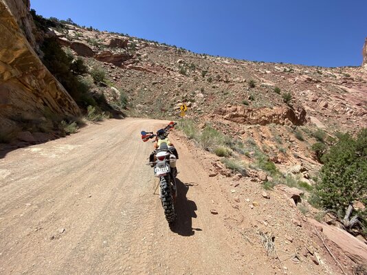
Notom road is paved into you cross into Capitol Reef NP. From there to the switchbacks, it is loose sand that does not get deeper than about a half foot. Both of our sand skills have increased tremendously and it was not much of a problem to run in 3rd and 4th gear through it today.

Lighten the front end, loosen your grip and look as far ahead as you can does the trick. Well, at least until the sand approaches 1 foot and then it gets a little weird.

B5C0A248-1D75-47FD-B30B-B88AEC5680B2.jpeg

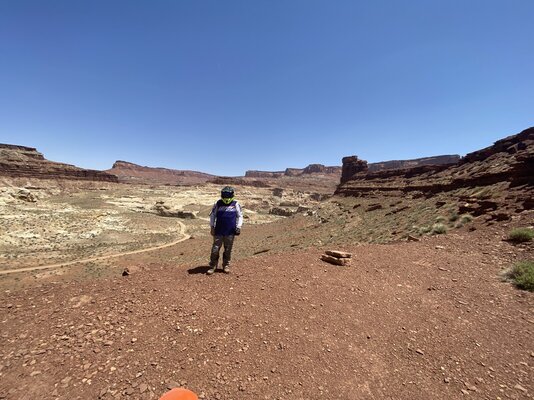
Just short of the switchbacks, we stopped here in Strike Valley for a break and some photos. The geology and layers out here resemble the spikes on a Stegosaurus. At least that is what I think.

21174A1F-5A55-47DB-82F9-33EC6DA8ABF6.jpeg

I have been seeing these pretty red flowers all over the place. Kind of strange how it appears to grow out of weeds or grass.

150E02E4-7CAF-4A9A-AED9-BC3F40F92872.jpeg

Jred with the eastern side of Strike Valley in view.

AA07EC75-6D5F-4BD5-ACD5-ED3C6A244F8F.jpeg

The slot that extends up to the base of the switchbacks.

EA8236EA-622A-4C63-BD82-9CEA0620326C.jpeg

At the bottom of the switchbacks, jred charges off to tackle them. The cliff seems small in this photo. I can assure you it is anything but.

0AF6B079-ED96-4BAF-9648-4F53DBC590BF.jpeg

The landscape turned super cool and I felt compelled to stop half way up to admire the view.

DB4F9074-CB6C-4920-8A2B-01F910235BBA.jpeg

Looking right towards the valley we just rode up from.

8116EF80-14DB-4719-B8D6-CECEF8CE8871.jpeg

And finally looking ahead. No bad views here. I got back on my bike and enjoyed the rest of the ride up. The turns are actually quite tight. I had a lot of fun spinning the rear tire around rather than trying to steer my way through them.

D6DA3C06-A0F9-4C1A-8799-E307AF01CBB4.jpeg

It only takes a few minutes to get on top. About two miles further, the Grand Staircase Escalante National monument comes into view.

E3817208-6E1D-4303-872E-E62AC56821EB.jpeg

There are so many photo opportunities that I really wish I had brought my GoPro along to get it all. With so many cool objects in sight, deciding when and where to stop is kind of a drag and of course I missed some things.
79A94CAF-B5F5-4772-941A-B3709C2B3E61.jpeg


3B329CFC-E76E-49AD-A7D3-C3D309F3C157.jpeg

Stopped for a short break right before we enter the prettiest canyon I think I have ever been through.

2CC240F9-70AF-4799-940B-D2BD08FB30E8.jpeg

Canyon walls started to get closer and the rock became redder.

2205E696-F604-4845-8536-E5762FDCA3AE.jpeg

The scenery just keeps on giving.

A7DBD927-5F0D-4390-87B2-06A85E6A8FBC.jpeg

Throughout this part of the ride I just kept wondering why I had not come through this part before. The scenery was just as good if not better than U 95.

2FE7CBBA-EE3B-4DD2-BD14-228A0A6547F1.jpeg

and just like U 95, a large arch in the making blew me away. I just love these things.

4D7D9659-D4F3-4842-A49C-14A9EE06618A.jpeg

The canyon gets narrower by the mile and goes for quite a long time. Most videos only capture a small part so it was a big surprise to see the whole thing.

6A86794A-2518-4D64-9B57-850FA8E6E288.jpeg

Here near the end of the canyon, some of the rock appeared to have a creamy looking texture.

AD79A2F3-EAE4-40B7-BCFC-4596BD6CD962.jpeg

Once out of the canyon, pinions and different colored layers returned to dominate the scenery. On the horizon is Boulder mountain where U 12 runs along the eastern ridges.

At the western end of the Burr trail is Boulder, Utah. A really cool little town I have been riding through for many years. The Burr trail grill was open so we stopped for a really good lunch. I usually stop at Nemos in Escalante to eat but I wont be doing that anymore.

Rather than double back towards Hanksville, we decided to ride U 12, another fantastic road over Boulder mountain towards Torrey. With only at shirt on under my jersey, it got pretty dang cold up there. My altimeter showed a max elevation of 9755 feet and there was still quite a bit of snow next to the road. There were deer also. Not the skinny things you see in Texas but some real beefy specimens. I was very happy to get past them without incident.

The ride over the pass on U 12 was just as fun, if not more so on the KTMs as compared to a street bike. We continued riding over the pass. and leaning into the corners which is always fun. I almost forgot I was freezing.

U 12 dead ends into U 24 at Torrey which is the town Capitol Reef National Park is nearest to.

D64E906D-6F12-422E-B5F8-A40E784BB280.jpeg

Heading east on U 24. This is right across from the goose necks. One could literally spend all day exploring and taking photos of the park but I already have so many from previous trips, I decided to take only a few at some of the better locations so I could prove the KTM had been there.

3D8F44E6-DCA0-4BBF-9D59-EA094AF3E00C.jpeg

One of the main Capitol Domes near the Petroglyphs.

5A5E4BF4-A49A-4ABC-A929-74839240BD7A.jpeg

The last photo I took of the day looking eastward towards Hanksville.

What I thought would be a routine kind of ride turned into visual overload. I have now ridden the entire Burr trail and highly recommend it. Big bike, small bike, it does not matter.

GPX viewer
 

Attachments

  • 7FE42DB0-F946-47E8-A2F8-216F0EAC6393.jpeg
    7FE42DB0-F946-47E8-A2F8-216F0EAC6393.jpeg
    601.3 KB · Views: 99
  • burr-trail.gpx
    burr-trail.gpx
    304.4 KB · Views: 89
Last edited:
Great photos! Using your phone or a dedicated camera for them?
All of these are from my phone without any enhancements. The scenery does all the work. 😀

To answer your other question specifically, from the north on Notom road to the switchbacks is about half pavement and half gravel. You will encounter sand on this route.

From the west at Boulder, it is probably 90% paved and the rest gravel with no sand I can remember.

From the south at Bullfrog- Lake Powell about 90% gravel and very light sand.

Well, that's it. It is time go home. I have been riding by this large sign all week. Times are changing in Hanksville.

bposter.jpg
 
Last edited:
I'd never make 5 miles in a day if I stopped for pics that much. I'd be jaw in my lap gawking at the beauty losing all track of time.
 
I am 0-3 on getting up for sunrise photos.

Hiked up the Great Sand Dunes at 4am. Clouds rolled over the mountains right before sunrise.
Hiked out to Grand Canyon, overcast skies, sun never showed up.
Hiked out to delicate arch, clouds rolled over the horizon right before sunrise.

I'd love to just once catch a photo like you have there but I seem to be bad luck, sorry to all those other folks that hiked out with me. :D
 
Back
Top