


-
 Welcome to the Two Wheeled Texans community!
  Feel free to hang out and lurk as long as you like. However, we would like to encourage you to register so that you can join the community and use the numerous features on the site. After registering, don't forget to post up an introduction!
You are using an out of date browser. It may not display this or other websites correctly.
You should upgrade or use an alternative browser.
You should upgrade or use an alternative browser.
Adding to my Nephew's first ride with a perspective from his side.
- Thread starter humanrace
- Start date
How super cool!
Don't look very slummy to me 
Looks like an old pro already! I'm looking at the elevation and gasping. 
- Joined
- Feb 28, 2003
- Messages
- 51,632
- Reaction score
- 9,205
- Location
- Huntsville
- First Name
- Scott
- Last Name
- Friday
Awesome!! When you are near the pass for Slumgullion, there is a great county road (CR 50) heading East from the camp area. If you follow that, you eventually come to a road that goes North (Cebolla Creek Rd.) and comes back out on CO 149 at Powderhorn. It is easy and would be good for two up on the V-Strom.
- Joined
- Oct 16, 2008
- Messages
- 3,789
- Reaction score
- 4,881
- Location
- Bryan, TX
- First Name
- Dennie
- Last Name
- Spears
My nephew's name is Malachi. He's 14 years old. He rode on back of a motorcycle for about a half mile and that was the extent of his riding until I asked him if he wanted to go on a trip with me. I had him write notes daily and I am going to use some excerpts of them in this report. They will be cut for length and content, but unedited otherwise. We pulled my toy box and took the VStrom in the camper.
Malachi's notes: Day 1- "Finally Tuesday the 28th the day I've been waiting for. It been about a month now since Uncle Dennie said he was taking me on a trip. I was so ready to get out of school." ....... I pointed out the sign for Pancake, Texas and explained that the town consisted of two houses and a water tank. He wrote something about there being a pancake shortage in Pancake, TX.
We stayed in Clovis, NM the first night and I was a little upset about his first sentence until I remembered that I didn't cook breakfast the next morning.
"Day 2 driving DAY part 2. We woke up around 7am and got us some breakfast it was good but not IHOP good
Our first view of snow.

We stayed two nights at the LaVeta Pines campground and really liked it except for the Ping Pong table. We played anyway.

We got set up in time to ride Highway 12 south to Stonewall. Why the town was named Stonewall. Lots of these, some much bigger.

One of the lakes along the way.

Before we got up too high, we found some early blooming Colorado Columbines.

We knew that Cordova Pass was closed, but I wanted to introduce him to a little dirt riding before we got to Silverton.

The obligatory snowball fight.


A quick snack to let the hands warm up.

The sun barely peeking through the dark clouds. Malachi asked for the electric jacket liner for the ride back. I think it was mainly for the novelty of having a heated garment for the first time ever.

A little scenery along the road back to the camper.


Excerpt from Malachi's notes. "Thursday May 30.....After me finally waking up me and Uncle Dennie got ready for yet another long ride on his bike but this time to Bishops Castle it was only about 60 miles but took an hour and half so to me it was long and after we explored and discovered cool misteries we headed back home the road we took was great chose due to the great view." By the way, these notes Malachi wrote will become part of my permanent collection.
More coming tomorrow.
Malachi's notes: Day 1- "Finally Tuesday the 28th the day I've been waiting for. It been about a month now since Uncle Dennie said he was taking me on a trip. I was so ready to get out of school." ....... I pointed out the sign for Pancake, Texas and explained that the town consisted of two houses and a water tank. He wrote something about there being a pancake shortage in Pancake, TX.
We stayed in Clovis, NM the first night and I was a little upset about his first sentence until I remembered that I didn't cook breakfast the next morning.
"Day 2 driving DAY part 2. We woke up around 7am and got us some breakfast it was good but not IHOP good
Our first view of snow.
We stayed two nights at the LaVeta Pines campground and really liked it except for the Ping Pong table. We played anyway.
We got set up in time to ride Highway 12 south to Stonewall. Why the town was named Stonewall. Lots of these, some much bigger.
One of the lakes along the way.
Before we got up too high, we found some early blooming Colorado Columbines.
We knew that Cordova Pass was closed, but I wanted to introduce him to a little dirt riding before we got to Silverton.
The obligatory snowball fight.
A quick snack to let the hands warm up.
The sun barely peeking through the dark clouds. Malachi asked for the electric jacket liner for the ride back. I think it was mainly for the novelty of having a heated garment for the first time ever.
A little scenery along the road back to the camper.
Excerpt from Malachi's notes. "Thursday May 30.....After me finally waking up me and Uncle Dennie got ready for yet another long ride on his bike but this time to Bishops Castle it was only about 60 miles but took an hour and half so to me it was long and after we explored and discovered cool misteries we headed back home the road we took was great chose due to the great view." By the way, these notes Malachi wrote will become part of my permanent collection.
More coming tomorrow.
Way to go Dennie! Every kid needs an uncle like you!
- Joined
- Oct 16, 2008
- Messages
- 3,789
- Reaction score
- 4,881
- Location
- Bryan, TX
- First Name
- Dennie
- Last Name
- Spears
I come close. Linda and I have more than 70 nieces and nephews. 19 of them are grand, grand nieces and nephews. Malachi is one of the grand grand.Way to go Dennie! Every kid needs an uncle like you!
- Joined
- Oct 16, 2008
- Messages
- 3,789
- Reaction score
- 4,881
- Location
- Bryan, TX
- First Name
- Dennie
- Last Name
- Spears
Our campground in LaVeta

The castle gate

The grand Bishops Castle


Looking at Malachi in the dome, from the steeple. Note the missing pieces of the dome right above his head and the bridge to nowhere. Actually, the bridge goes to a very steep and long drop-off.

As I have said in previous posts, nothing at the castle gets finished. Also, very little gets repaired. Some pieces for the dome are missing, there are holes in the stairs and walkways are incomplete. OSHA would have a fit.

After the castle, we took the long way back to camp. A Butt not yet accustomed to motorcycle seats, needed a rest. We took the van to Great Sand Dunes.
Malachi's notes. "We got back to camp hoped in the Van and drove another 60 miles to Great Sand Dunes National Park (Did not climb to the top) then we went to a waterfall I fell and had ice in my pants for about 5 minutes I also learned things Uncle Dennie will stop to talk to everybody and glacier water is cold!!!!
Editors note-The waterfall was running over ice about 50' upstream from where Malachi fell into the water.
Along the way.

This dead tree was close to a convenient stop.

The creek was as wide as I have ever seen it.

Surfing is encouraged.

Malachi did not attempt this dune and neither did anyone else.


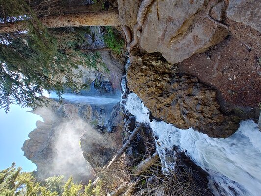
On to the waterfall just outside the park.
I suggested that Malachi cross the creek right about where I was standing when I took this picture. He declined so he could keep his feet out of the cold water until it was absolutely necessary.

The ranger told us the water was around 40*. I Believed her. If you are wondering why I didn't spring to his aid, it's because there is a ranger stationed downstream just for that purpose. The water is deadly cold.
Our last night at LaVeta Pines

The castle gate
The grand Bishops Castle
Looking at Malachi in the dome, from the steeple. Note the missing pieces of the dome right above his head and the bridge to nowhere. Actually, the bridge goes to a very steep and long drop-off.
As I have said in previous posts, nothing at the castle gets finished. Also, very little gets repaired. Some pieces for the dome are missing, there are holes in the stairs and walkways are incomplete. OSHA would have a fit.
After the castle, we took the long way back to camp. A Butt not yet accustomed to motorcycle seats, needed a rest. We took the van to Great Sand Dunes.
Malachi's notes. "We got back to camp hoped in the Van and drove another 60 miles to Great Sand Dunes National Park (Did not climb to the top) then we went to a waterfall I fell and had ice in my pants for about 5 minutes I also learned things Uncle Dennie will stop to talk to everybody and glacier water is cold!!!!
Editors note-The waterfall was running over ice about 50' upstream from where Malachi fell into the water.
Along the way.
This dead tree was close to a convenient stop.
The creek was as wide as I have ever seen it.
Surfing is encouraged.
Malachi did not attempt this dune and neither did anyone else.
On to the waterfall just outside the park.
I suggested that Malachi cross the creek right about where I was standing when I took this picture. He declined so he could keep his feet out of the cold water until it was absolutely necessary.
The ranger told us the water was around 40*. I Believed her. If you are wondering why I didn't spring to his aid, it's because there is a ranger stationed downstream just for that purpose. The water is deadly cold.
Our last night at LaVeta Pines
Last edited:
- Joined
- Oct 16, 2008
- Messages
- 3,789
- Reaction score
- 4,881
- Location
- Bryan, TX
- First Name
- Dennie
- Last Name
- Spears
We did 4 days of dirt riding when we got back. Mom was chomping at the bit with anxiety, but after three weeks away, we drove right past her house and on to my house.Good times for sure. I've got a feeling young Malachi has a motorcycle in his future.
- Joined
- Oct 16, 2008
- Messages
- 3,789
- Reaction score
- 4,881
- Location
- Bryan, TX
- First Name
- Dennie
- Last Name
- Spears
Malachi's notes-"So today is an easy driving day were going from La Veta to South Point, Co it's only about 150 miles.......we got everything organized unloaded the bike & headed towards Wolf Creek Pass it was really nice" South Fork, not South Point.
Wolf Creek Pass


Less than 1/4 mile back is a runaway ramp. This driver should have played the "what if" game so the decision to take the runaway ramp if the brakes overheated was made way before reaching this point.


Lunch before heading to Creede and Lake City

Rio Grande

Me keeping Malachi from repeating his swimming lesson, this time in a creek that runs through Creede.

We were going to take the dirt loop north of Creede. The start.

I'm not sure why this small dam was built.

So much for doing the loop.

Maybe I could say I didn't see the sign and just went through the gap.

It wouldn't matter, I later found out the road was blocked by a rockslide. I could have gone the other direction and seen most of the loop, but we decided to go to a waterfall instead. This is something to do with an old mine.

The citizens of Creede have blasted a fake mine next to the underground fire station. We didn't tour it because we knew we were going to tour a real gold mine in Silverton. The gift shop sign was like a magnet for Malachi, so we went inside. I hope the citizens of Creede didn't pay for this sign.

We ditched Highway 149 for this dirt road that rejoins 149 at North Clear Creek Falls. Malachi has disappeared.

The typical view from the parking lot. It's OK.

10 minutes of scrambling will get you this view.

30 minutes will get you to the bottom. The hike comes with a free cardio workout. Note my new stomach bulge. It's caused by Newton's corollary, the farther one is away from the bike, the more likely one is going to need the camera lens left in the tank bag.

I need to talk to that boy about composing his pictures.

A lake damned by the Slumgullion earthflow. The earth slide has been moving for many years and is still moving at about 23 feet per year.

Malachi's notes-"So today wasn't a very much anything we met a few people, but today me and Uncle Dennie left later than usual. We ate breakfast but both of us were a little sleepy so we took us a little an hour and half power nap....On the way back we stoped for an ice cream cone and Uncle lost his glasses (in his pocket)"
Day 6 notes-"Today is not much of anything were heading to Silverton.......we checked in unpacked and left on the motorbike Ouray, Co it was one of the most beautiful places I have ever seen"
Along the road to Silverton, we stopped at Treasure Falls

I believe it's against the law to drive past Molas pass without stopping for pictures. If you start hiking outside of Denver and hike cross country for 408 miles, you will be at Molas Pass and 70 miles from the end of the Colorado Trail. I highly recommend that you do that hike.

There's the Colorado Trail right behind Malachi with Denver only 862,000 steps away.

Malachi said Ouray is a 10/10 place to visit. Pictures tomorrow.
Wolf Creek Pass
Less than 1/4 mile back is a runaway ramp. This driver should have played the "what if" game so the decision to take the runaway ramp if the brakes overheated was made way before reaching this point.
Lunch before heading to Creede and Lake City
Rio Grande
Me keeping Malachi from repeating his swimming lesson, this time in a creek that runs through Creede.
We were going to take the dirt loop north of Creede. The start.
I'm not sure why this small dam was built.
So much for doing the loop.
Maybe I could say I didn't see the sign and just went through the gap.
It wouldn't matter, I later found out the road was blocked by a rockslide. I could have gone the other direction and seen most of the loop, but we decided to go to a waterfall instead. This is something to do with an old mine.
The citizens of Creede have blasted a fake mine next to the underground fire station. We didn't tour it because we knew we were going to tour a real gold mine in Silverton. The gift shop sign was like a magnet for Malachi, so we went inside. I hope the citizens of Creede didn't pay for this sign.
We ditched Highway 149 for this dirt road that rejoins 149 at North Clear Creek Falls. Malachi has disappeared.
The typical view from the parking lot. It's OK.
10 minutes of scrambling will get you this view.
30 minutes will get you to the bottom. The hike comes with a free cardio workout. Note my new stomach bulge. It's caused by Newton's corollary, the farther one is away from the bike, the more likely one is going to need the camera lens left in the tank bag.
I need to talk to that boy about composing his pictures.
A lake damned by the Slumgullion earthflow. The earth slide has been moving for many years and is still moving at about 23 feet per year.
Malachi's notes-"So today wasn't a very much anything we met a few people, but today me and Uncle Dennie left later than usual. We ate breakfast but both of us were a little sleepy so we took us a little an hour and half power nap....On the way back we stoped for an ice cream cone and Uncle lost his glasses (in his pocket)"
Day 6 notes-"Today is not much of anything were heading to Silverton.......we checked in unpacked and left on the motorbike Ouray, Co it was one of the most beautiful places I have ever seen"
Along the road to Silverton, we stopped at Treasure Falls
I believe it's against the law to drive past Molas pass without stopping for pictures. If you start hiking outside of Denver and hike cross country for 408 miles, you will be at Molas Pass and 70 miles from the end of the Colorado Trail. I highly recommend that you do that hike.
There's the Colorado Trail right behind Malachi with Denver only 862,000 steps away.
Malachi said Ouray is a 10/10 place to visit. Pictures tomorrow.
Attachments
- Joined
- Feb 28, 2003
- Messages
- 51,632
- Reaction score
- 9,205
- Location
- Huntsville
- First Name
- Scott
- Last Name
- Friday
I tried getting Daniel and Sarah to keep notes or make short daily recap videos of our big trip, but they wouldn't do it. I tried getting them to upload their pics and share their thoughts on the ride report thread I had running, but they wouldn't do it  So it is cool he kept notes, even if kind of minimal
Ahh, but the memories they will have forever, and later in life, they will remember and thank you for them.I tried getting Daniel and Sarah to keep notes or make short daily recap videos of our big trip, but they wouldn't do it. I tried getting them to upload their pics and share their thoughts on the ride report thread I had running, but they wouldn't do it
And I've got the perfect bike for him in the for sale section (shameless plug)!Good times for sure. I've got a feeling young Malachi has a motorcycle in his future.

- Joined
- Oct 16, 2008
- Messages
- 3,789
- Reaction score
- 4,881
- Location
- Bryan, TX
- First Name
- Dennie
- Last Name
- Spears
Outside Ouray


That's the Uncompahgre River to Malachi's right. Ouray uses that cold water to regulate the temperature of the hot springs in the public pools. Filter? Heat exchanger?

Red mountain.

In 1993, seven of us went to Animas Forks on an FZR-1000, a GS-1000 with full touring package, an FJ-1100, an Interceptor 500, a 700 Maxim X and two other unremembered bikes. I hit my bash plate twice on my Vstrom. The sign at Eureka now says 4WD beyond this point.


Modern outdoor toilet in 2024.

A modern indoor toilet in 1880.

This house was built and abandoned in a period of 3 years. Apparently, the dining room addition to the right side of the house was considered an extreme luxury in 1890.

A nice house in its day, but with the exception of indoor toilets, not luxurious.

Headed back to camp.

Our lunch. We would make up for the splurge by having meat, beans and fruit for dinner.

Still enough time to ride the San Juan Skyway loop today if we hurry. Pics coming up as well as Jeep roads blocked by snow.
That's the Uncompahgre River to Malachi's right. Ouray uses that cold water to regulate the temperature of the hot springs in the public pools. Filter? Heat exchanger?
Red mountain.
In 1993, seven of us went to Animas Forks on an FZR-1000, a GS-1000 with full touring package, an FJ-1100, an Interceptor 500, a 700 Maxim X and two other unremembered bikes. I hit my bash plate twice on my Vstrom. The sign at Eureka now says 4WD beyond this point.
Modern outdoor toilet in 2024.
A modern indoor toilet in 1880.
This house was built and abandoned in a period of 3 years. Apparently, the dining room addition to the right side of the house was considered an extreme luxury in 1890.
A nice house in its day, but with the exception of indoor toilets, not luxurious.
Headed back to camp.
Our lunch. We would make up for the splurge by having meat, beans and fruit for dinner.
Still enough time to ride the San Juan Skyway loop today if we hurry. Pics coming up as well as Jeep roads blocked by snow.
- Joined
- Oct 16, 2008
- Messages
- 3,789
- Reaction score
- 4,881
- Location
- Bryan, TX
- First Name
- Dennie
- Last Name
- Spears
We didn't hurry. Instead, we walked around town and goofed off before heading back to camp for dinner.
Per Malachi's notes-"We got back to camp to late to wash cloths" (insert drawn in smiley face) "we ate pork chops they were so so good and we had a side of beans and strawberries."
I'm going to defend myself here. We were indeed going to wash clothes when we got back to camp, but it's the only time we wore anything two days in a row. Also, I appreciate the accolades for my pork chop cooking abilities, but the beans and strawberries were separate dishes.")
San Juan Loop with side trips thrown in since we have a complete day. Neither my wife nor Malachi's mom were given a return date. We are taking our time.

We stopped several times for pictures between Silverton and Durango.

Once, we made an unintended stop. The vehicle is an unmarked gray pickup. The officer chastised us both for laughing by saying, "Speeding is not a laughing matter." We both concurred but explained that the consequences that I would face when his mother and my wife found out that I passed a policeman going 75 MPH in a 50 MPH speed zone, with my nephew behind me, were definitely a laughing matter. At least it was funny to Malachi. No ticket was issued.

Onward to the roadside warm springs.

The Following pictures are along the San Juan Loop between the hot springs and the turn to Alta Lakes, some from my camera and others from my phone. They may not be in order since I apparently lack the technical knowledge to synchronize the time and date for the camera and phone.


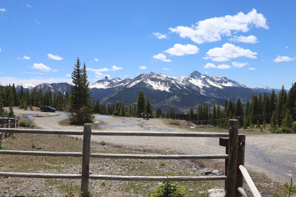
The mountains were beautiful in early June.

We decided to do a little dirt riding to the ghost town of Alta and to the beautiful lakes that are named after the towns. I told Malachi the lakes would be our picnic area.
Alta Ghost town.


Note that our altitude is close to the altitude where the snow starts on the adjacent mountain.

Right around the corner is a snow blockage of the road to the lakes.

We ate with the ghost and the beavers.

A few more pics of beauty before heading back to the highway.


Malachi with a sign of his newly found love of things electric hanging out from under his jacket.

Nearly unreadable signs at a roadside turnout for the first commercial electrical generating plant in the US. They explain how Tesla (AC) beat out Edison (DC) and how we now have AC electricity throughout the world.


While posting these pictures, I found my problem with my jumbled-up and out of sync pictures. With no phone service for a couple of hours, my phone said a large group of pictures were taken at 12:00 when they were actually taken over a two-hour span. When I uploaded them to my computer, they were loaded randomly.
On to another side trip to Telluride and Bridal Veil Falls. We opted to walk the trail to Bridal Veil so we could see all three falls along the river.

The structure at the top of Bridal Veil Falls is the second commercial power plant built in the US. Both were built to power equipment in mines.

Along the trail but hidden from view from the road. A waterfall and Malachi and his new binoculars given to him by our camp host

Looking back towards Telluride.

Altitude and strenuous hiking affected Malachi several times.

I can't find a picture of the second waterfall along the trail, but here's a link to a video.
A view of Bridal Veil from along the road back. We opted not to take the trail back since it was getting kind of late.

Somehow, Malachi skipped a day of writing notes. There's nothing about waterfall or Telluride at all.
Per Malachi's notes-"We got back to camp to late to wash cloths" (insert drawn in smiley face) "we ate pork chops they were so so good and we had a side of beans and strawberries."
I'm going to defend myself here. We were indeed going to wash clothes when we got back to camp, but it's the only time we wore anything two days in a row. Also, I appreciate the accolades for my pork chop cooking abilities, but the beans and strawberries were separate dishes.
San Juan Loop with side trips thrown in since we have a complete day. Neither my wife nor Malachi's mom were given a return date. We are taking our time.
We stopped several times for pictures between Silverton and Durango.
Once, we made an unintended stop. The vehicle is an unmarked gray pickup. The officer chastised us both for laughing by saying, "Speeding is not a laughing matter." We both concurred but explained that the consequences that I would face when his mother and my wife found out that I passed a policeman going 75 MPH in a 50 MPH speed zone, with my nephew behind me, were definitely a laughing matter. At least it was funny to Malachi. No ticket was issued.
Onward to the roadside warm springs.
The Following pictures are along the San Juan Loop between the hot springs and the turn to Alta Lakes, some from my camera and others from my phone. They may not be in order since I apparently lack the technical knowledge to synchronize the time and date for the camera and phone.
The mountains were beautiful in early June.
We decided to do a little dirt riding to the ghost town of Alta and to the beautiful lakes that are named after the towns. I told Malachi the lakes would be our picnic area.
Alta Ghost town.
Note that our altitude is close to the altitude where the snow starts on the adjacent mountain.
Right around the corner is a snow blockage of the road to the lakes.
We ate with the ghost and the beavers.
A few more pics of beauty before heading back to the highway.
Malachi with a sign of his newly found love of things electric hanging out from under his jacket.
Nearly unreadable signs at a roadside turnout for the first commercial electrical generating plant in the US. They explain how Tesla (AC) beat out Edison (DC) and how we now have AC electricity throughout the world.
While posting these pictures, I found my problem with my jumbled-up and out of sync pictures. With no phone service for a couple of hours, my phone said a large group of pictures were taken at 12:00 when they were actually taken over a two-hour span. When I uploaded them to my computer, they were loaded randomly.
On to another side trip to Telluride and Bridal Veil Falls. We opted to walk the trail to Bridal Veil so we could see all three falls along the river.
The structure at the top of Bridal Veil Falls is the second commercial power plant built in the US. Both were built to power equipment in mines.
Along the trail but hidden from view from the road. A waterfall and Malachi and his new binoculars given to him by our camp host
Looking back towards Telluride.
Altitude and strenuous hiking affected Malachi several times.
I can't find a picture of the second waterfall along the trail, but here's a link to a video.
A view of Bridal Veil from along the road back. We opted not to take the trail back since it was getting kind of late.
Somehow, Malachi skipped a day of writing notes. There's nothing about waterfall or Telluride at all.
Attachments
Couldn't coax a smile out of the LEO, huh?