Feel free to hang out and lurk as long as you like. However, we would like to encourage you to
 _RG_
Forum Supporter
I drew pictures of airplanes and bunnies in geography class so it came as some surprise that Moab is only 150 miles up the road from Ouray. Kind of stumbled into this little epiphany by accident. This ride was a quick extension of our trip to Ouray.
Going NW from Ouray toward Moab the land changes dramatically from Rocky Mountains into sandstone topography of the desert.
This is in Ridgeway, about 10 miles north of Ouray.

Along the way...old barns are cool. They each have a personality if you look closely enough.

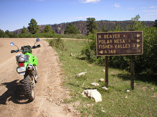
Never know what lies along a trail...

The land changes pretty quick. You see the La Sal mountains from a long ways.

The Rockys morph into these sandstone bluffs in a remarkably subtle fashion.

Some distance still from Moab, there's a noticeable change in geology.


Moab is a colorful community along the banks of the Colorado. The locals seem to take pride in their independence and incongruous freedoms. Everyone I visited with there is an import from somewhere else. They visited Moab, fell in love with the land and it's people, and came back to stay. Great folks.

Of coarse the first trail is out to the Arches. Got there about an hour before sunset so the light was really kind to my junky little camera.
Not bad for an old point and shoot that bangs off the handlebars every time I saddle up.


Next morning it was east out Sand Flats road to the La Sal mountains. I took a couple of side trails and found they come in two flavors...rock and sand. The rock is solid sandstone and grips a D606 like new asphalt. The sand, however, is loose and deep.

If deep sand is a challenge, practice in it a lot before coming to Moab.


You can see the La Sals for 50 or 60 miles before getting close to them. The climb up is a good road. If running tight twisties is your joy, you'll giggle till you choke on this hill.

It gets considerably cooler as you climb.

It's open range and all the cattle know it, too.

This looks like your at the top of the world. Pictures always flop in these scenes but the view is truly something to behold firsthand.


Right on top of the mountain is this radio tower. Checking my cell phone showed great signal strength. So what should I do? That's right...call everybody I know and tell them what a cool view I have.

A few folks live up here...talk about isolation and independence...with a view...works for me.

The higher elevations are more alpine with lots of vegetation and docile mule deer all over the place.


At the end of one little side trail (by end of the trail I mean it literally drops over the edge of the world and we discover just how well our brakes are working today)


Came back down the mountain through the same valley I saw from on high. Very red rocks.

River Road back to Moab.

After lunch it was out west to Canyon lands and Dead Horse Point...the back way of coarse.
Pitcher handle arch on River Road. This marks the entrance to Long Canyon... a very cool canyon ride.


You start on the canyon floor...and climb.

Near the top of the canyon is Pucker Pass. There's a good reason for this name. The road goes under a huge fallen rock and it get a bit loose and gnarly for a spell. Very do-able.
On top...


This drops you at the entrance to Dead Horse Point.


If you look closely at the shelf way down by the river, you'll see part of Shafer Trail.

Next, it was further west to the Canyon lands.


The Shafer Trail goes from Canyon Lands to along the river at Dead Horse. It starts off on the plateau and winds down the side of a canyon toward Moab. It's about a 22 mile ride that involves a very narrow shelf road and some tight switchbacks. This is one that'll keep you focused. I took a great picture looking straight down at several switchbacks but the camera choked on dust and well...just quit on me.

My only regret is the short time I had in Moab. There are trails all over the place. A person could spend a week riding and still just be getting started...and love every minute. I shall return...
Going NW from Ouray toward Moab the land changes dramatically from Rocky Mountains into sandstone topography of the desert.
This is in Ridgeway, about 10 miles north of Ouray.
Along the way...old barns are cool. They each have a personality if you look closely enough.
Never know what lies along a trail...
The land changes pretty quick. You see the La Sal mountains from a long ways.
The Rockys morph into these sandstone bluffs in a remarkably subtle fashion.
Some distance still from Moab, there's a noticeable change in geology.
Moab is a colorful community along the banks of the Colorado. The locals seem to take pride in their independence and incongruous freedoms. Everyone I visited with there is an import from somewhere else. They visited Moab, fell in love with the land and it's people, and came back to stay. Great folks.
Of coarse the first trail is out to the Arches. Got there about an hour before sunset so the light was really kind to my junky little camera.
Not bad for an old point and shoot that bangs off the handlebars every time I saddle up.
Next morning it was east out Sand Flats road to the La Sal mountains. I took a couple of side trails and found they come in two flavors...rock and sand. The rock is solid sandstone and grips a D606 like new asphalt. The sand, however, is loose and deep.
If deep sand is a challenge, practice in it a lot before coming to Moab.
You can see the La Sals for 50 or 60 miles before getting close to them. The climb up is a good road. If running tight twisties is your joy, you'll giggle till you choke on this hill.
It gets considerably cooler as you climb.
It's open range and all the cattle know it, too.
This looks like your at the top of the world. Pictures always flop in these scenes but the view is truly something to behold firsthand.
Right on top of the mountain is this radio tower. Checking my cell phone showed great signal strength. So what should I do? That's right...call everybody I know and tell them what a cool view I have.
A few folks live up here...talk about isolation and independence...with a view...works for me.
The higher elevations are more alpine with lots of vegetation and docile mule deer all over the place.
At the end of one little side trail (by end of the trail I mean it literally drops over the edge of the world and we discover just how well our brakes are working today)
Came back down the mountain through the same valley I saw from on high. Very red rocks.
River Road back to Moab.
After lunch it was out west to Canyon lands and Dead Horse Point...the back way of coarse.
Pitcher handle arch on River Road. This marks the entrance to Long Canyon... a very cool canyon ride.
You start on the canyon floor...and climb.
Near the top of the canyon is Pucker Pass. There's a good reason for this name. The road goes under a huge fallen rock and it get a bit loose and gnarly for a spell. Very do-able.
On top...
This drops you at the entrance to Dead Horse Point.
If you look closely at the shelf way down by the river, you'll see part of Shafer Trail.
Next, it was further west to the Canyon lands.
The Shafer Trail goes from Canyon Lands to along the river at Dead Horse. It starts off on the plateau and winds down the side of a canyon toward Moab. It's about a 22 mile ride that involves a very narrow shelf road and some tight switchbacks. This is one that'll keep you focused. I took a great picture looking straight down at several switchbacks but the camera choked on dust and well...just quit on me.
My only regret is the short time I had in Moab. There are trails all over the place. A person could spend a week riding and still just be getting started...and love every minute. I shall return...