- Joined
- Dec 8, 2014
- Messages
- 1,154
- Reaction score
- 4,050
- Location
- San Marcos, Texas
- First Name
- Steve
- Last Name
- Pylant
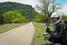
Couple pics that wouldn't load from my phone in the field....panos.


 Feel free to hang out and lurk as long as you like. However, we would like to encourage you to register so that you can join the community and use the numerous features on the site. After registering, don't forget to post up an introduction!

AKA... TEXASThe most true thing Steve has ever said.
I know the drama well, having dodged many storms with lightning bolts for legs in Colorado and Utah. Great reporting!The dark clouds.....it was adding to the drama that day as well
Fully agree with your avoidance of cities, interstates and highways in general. I have been using Ride With GPS for the past couple of years for my route planning and ride tracking which has worked out great but I still use GE on the fly with things don't go as planned...Its a combination of things that I do I guess. First up, interstates are the devil, pretend they don't exist. Big cities, never route anywhere near them. From there, I will talk out loud about each section and kind of how this ride took shape, all my routes start this way.
Colorado
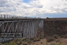
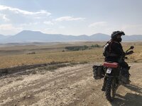
The Colorado stuff kind of shaped itself. The truck transport went to my friend's family cabin in Empire night 1. So I have my start. I knew from there I didn't want to go back east towards Denver, I wanted to go south. Started researching the dirt passes, most all of them do not open till Memorial weekend....or later. So I just looked for secondary roads that accomplished the direction I wanted to go and did the best I could. Even those involved passes, looked them up on Colorado DOT type sites, they were open. Once I was a couple hours south, I knew that Fairplay/BV/Salida area had that desert terrain between the mountain ranges from being in the area on past trips....that's my zin so I focused on obvious forest service areas and if not, looked for interesting looking county roads based on not going in a straight line. Used Basecamp and just picked roads that mostly kept me going southerly. Also used Google Earth to look for any cool attractions, like the mine I spotted. I knew being cold/wet at night was a high possibility in Colorado in May, so I removed camping from the equation on this run....and I knew there was a KOA in Alamosa, so I had my end target. The dunes were added cause I knew they were close and hoped to pull that off, even though they were ready to be my sacrificial lamb if time ran out. For the second day, I knew from past truck overlanding that southern Colorado and northern NM have a lot of dirt roads in that desert valley. So pavement was out. I also quickly spotted a route hitting dirt almost immediately across from the KOA and figured semi-following the Rio Grande river valley would be cool....and found county roads doing that. Looked at GE a lot in that area. I could see the big bridge was legit.
New Mexico
I knew where the NMBDR popped out on the last section (not too far from Alamosa) and the fact that I missed it my first go round. Loaded that track and then plotted my moves to get into the Tres Piedras area. I knew I wanted to end up in Angel Fire at my other buddy's place, so I just had to fill in the gap. My original thought was go further south to make the most use of dirt from Ranch De Taos to Angel Fire, but the weather stopped that. So I adlibbed on the fly using my nose and GPS that day, look at sky, look at map, look at throttle. To leave Angel Fire day 3, I played with the thought of trying to get on the Shadow of the Rockies route (from Sam) as quick as possible. But it was too far east in the northern section of the state, abandoned that. So I went back to basecamp, again looking for long county roads. Spotted those two good ones right off, just worried about map lies. But I looked on GE on each end where you can use street view, then double check flying over the top with regular GE, and routinely make sure the name of the road stays the same all the way through, that ups the chances. Stitch the dirt together with secondary/FM type roads.
Texas
Just punch yourself in the face over and over again. Probably more productive, ha ha. Seriously though, same thing, long county dirt roads. Its going to be boring, so I zoom out on GE and look for interesting topography/rocks/drainage, big rivers, bridges, historical stuff. I didn't get to do everything I planned this last time, so I have some things that stand out for the future. So sometimes in Texas I will have that in the back of my head, past trip highlights that didn't work out. I look for non-straight roads whether dirt of secondary/FM. Only graduate to state highways if absolutely necessary.
Probably too much rambling....but there is no quick answer. It involves some finesse and a big picture view I guess....and time. I've always been pretty decent at sniffing things out. And yes I will try to get local intel if possible, ADVR has helped there on some of my other trips. And any time I read a cool ride report and/or see tracks shared, I download them, regardless if it is on my current radar. Hope that helps. Oh, and I always draw from the power of nuns as well.
View attachment 349696
View attachment 349697