• Welcome to the Two Wheeled Texans community! Feel free to hang out and lurk as long as you like. However, we would like to encourage you to register so that you can join the community and use the numerous features on the site. After registering, don't forget to post up an introduction!

Mountains, Rivers, Canyons, Lakes, Statues and Oddities, Both Domestic and Foreign, Then Repeat

There were three different clerks and there was a big screen monitor facing the customer, and behind the clerk. Pictures changed about every 30 seconds and they were all beautiful shots from around the Sturgis area. I had gotten to know all three by asking directions to different pictures I saw on the screen. Also, all three were enamored by me because they couldn't believe I would go riding around the area every day while it was raining.
 
So they felt sorry for the crazy old motorcycle dude? :lol2: I'll have to try that angle some time... :trust:
 
I was riding through the small town of Silverton and saw a sign giving directions to a museum. I turned left. It was closed, but
IMG_8368.JPG


An old air compressor.
IMG_8370.JPG


There were lots of old tools. I liked this drill press best. I've seen a similar one in a building with a common power supply for all of them. A water wheel would turn a shaft and all machines in the building were powered by an overhead shaft. A lever would tighten the flat belt that powered each machine as the belts were tightened. Note the high speed and low speed spindle gears. Can you imagine someone getting a finger caught in those?
IMG_8373.JPG


IMG_8389.JPG


I am scouting places to take Linda, so some of the pictures I post later may seem familiar. I know we came back to this roadside park and took pictures.
IMG_8390.JPG


I stayed in the Nakusp city campground. One of my neighbors was James. Remember that name, it comes up again. James is from New Zealand. He uses a gunny sack for seat bag, he's more frugal than me. He rides hard and his bike shows it.
IMG_20230604_072954252.jpg


Like I said, he's more frugal than I. I opted for a Jet Boil while James uses an empty can. He's on an extended trip and it's not his first one. Note the bent handle on his spoon. I know the bent handle has a purpose, but I wasn't around to witness its use.
IMG_20230604_073151009.jpg


Another neighbor was Dale. Remember that name. It also comes up again. Dale has a shiny bike. James and I do not. After talking to Dale for a few minutes, I realized he had a lot of knowledge about bikes, trails and dual sport riding. His bike is shiny because he lives about 300 kilometers away and is just getting started on a trip. After talking to him for a while, I know that I want to lead if we ride together, because I don't want to be left behind.
IMG_20230604_073850879_HDR.jpg

My brother has recently died from Covid. He was an avid rider and bought his first new bike, a 1980 model Harley Sturgis, after riding Triumphs for several years. I've gone on lots of rides with my brother, but his best friend has gone on many more than I have, mainly because they both ride Harleys and I ride a lot of dual sport rides. We always camped on our rides. My brother's name was James and his best friend's name is Dale. I camped with James and Dale last night.

I woke up early and left before James and Dale got up. The sunrise at 4:00 AM because of how far north I was really messed with my system. I was a little surprised when I got to the ferry and was the only one in line. A worker came over and told me the ferry had hit a log, they were replacing one of the power drives and the next ferry would leave in about 6 hours, maybe.
IMG_20230604_091306932_HDR.jpg

I decided to take a dirt road that had been recommended by Dale. It took me away from my destination, but I wasn't about to wait until 3:00 PM to maybe get on a ferry.

I had a regional map that said gas was available here. When I saw the "pumps," I stopped even though I didn't need gas.
IMG_20230604_094901520_HDR.jpg


Yes, they work.
IMG_8398.JPG


I'm glad I didn't wait.
IMG_8396.JPG


IMG_20230604_095529762.jpg


IMG_20230604_100614328_HDR.jpg


IMG_8412.JPG


I came upon a bridge that wasn't down for repairs.
IMG_8417.JPG


At the end of the dirt road was a campground for motorcycles only. Being a motorcycle only campground made it unusual, but that was just the beginning.
IMG_20230604_162520115.jpg
 

Attachments

  • IMG_20230604_094901520_HDR.jpg
    IMG_20230604_094901520_HDR.jpg
    217.2 KB · Views: 56
Last edited:
Welcome to Toad Rock campground. Not your normal cqmpground.
IMG_20230604_162710471_HDR.jpg


IMG_20230604_185145687_HDR.jpg


Women could get their hair done while ........., well, there is a toilet paper dispenser, but I'm not sure if the toilet or the hair dryer actually work.
IMG_20230604_190238141.jpg


Make your own change.
IMG_20230604_190255455.jpg


A covered area is available if you need a hydraulic lift, tire machine or tools. A little cluttered.
IMG_20230604_190316456.jpg


Some upscale campgrounds will not accept campers less than 30' or older than 10 years. The Toad Rock also tries to weed out undesirable campers.
IMG_20230604_190440714.jpg


IMG_20230604_190553321.jpg


I don't think the Toad has a liquor license, but you can serve yourself a beer or two at the community area and make a donation if you want. Coffee and tea are available in the morning. Also donations accepted. There are lots of accommodations if you don't have a tent. The green trailer is available. So is a school bus, several cabins and some trucks that could have been food trucks in the past. Sleeping bags, sheet and pillows are available to rent.
IMG_20230605_092857382.jpg
 

Attachments

  • IMG_20230605_095612967.jpg
    IMG_20230605_095612967.jpg
    582.1 KB · Views: 58
My luck with ferries is bad. Here I am, there you go.
IMG_20230605_095612967.jpg


June 5th, so winter schedule is still going strong. What to do for one hour and 40 minutes?
IMG_20230605_095802314_HDR.jpg


Let's see, what can I do for an hour and 40 minutes. Ferries in fresh water are free. Not in salt water.
IMG_20230605_113208715_HDR.jpg


IMG_20230605_120210761.jpg


Years ago, a mortician decided not to throw any more empty embalming fluid jars in the trash. His fellow morticians joined in until they had enough to build a house.
IMG_8428.JPG


IMG_8429.JPG


Not all work was done with glass
IMG_8436.JPG


The end result was a cozy house and an empty garbage can.
IMG_8439.JPG


If I were a mortician, I would have a casket coffee table an a casket entertainment center.
IMG_8442.JPG


He was also a hunter.
IMG_20230605_135959141.jpg


But not a very discriminating one.
IMG_20230605_140012701.jpg


This picture was in the cull pile because I thought I was posting too many pictures. I changed my mind. Another lake with a road running at the base of a cliff.
IMG_20230607_140356025_HDR.jpg


June 6th, Waterton NP and a visit by my wife coming up, but first I must do a tune up on my new DRZ and put some suitable tires on it. My old bike is sold. It cost me $2,100 in bike depreciation to ride two years and 34,000 miles.
 

Attachments

  • IMG_8441.JPG
    IMG_8441.JPG
    509.7 KB · Views: 50
  • IMG_20230605_095802314_HDR.jpg
    IMG_20230605_095802314_HDR.jpg
    364.3 KB · Views: 50
Exxon is ESSO in Canada. I remember ESSO being changed to EXXON a long time ago in the US. When Standard Oil was broken into many companies, one of them went with ESSO, pronounced S O, the initials for Standard Oil. Other companies that were part of the break-up of Standard Oil objected, but it wasn't until years later that the name was changed to Exxon in the US.
IMG_8446.JPG


Rivers and bridges. This one on the way to Banff NP from the west.
IMG_8454.JPG


Highway 93 goes through a slot canyon close to Radium Hot Springs
IMG_8459.JPG


The view of one of the mountains in Banff, from the back side.
IMG_8466.JPG


I rode through Banff and Jasper, but pictures will have to wait until I come back with Linda. I don't want to duplicate too many times. More extensive pics with Linda since we were not on such a tight schedule. I got distracted too many times back in Washington state and ran out of time to get back to Kalispell in time. I hurried.
I stopped for this fence because I thought Linda would not want to stop. Hats in both directions and they go over the hill in both directions.
IMG_8470.JPG


I needed a place to leave my bike while Linda was with me. Her new hip is a problem when riding on the skinny DRZ seat and just getting her riding gear to Montana would have been a problem. We rented a car for 16 days.

I met the owner of this company coming down a dirt road near my campground. We talked for 30 minutes or more. He rents dirt bikes and guides the excursions. I casually mentioned that I needed a place to store my bike for two weeks and he told me to take a picture of his truck, with the phone number, and he would clean out a spot in his warehouse. It turned out the local car rental company I used had a mechanic that rode. He allowed me to store the DRZ in the shop for 16 days.
IMG_8471.JPG


I had returned to camp near the Hungry Horse Dam, a 564' tall arched concrete dam.
IMG_20230607_200025624_HDR.jpg


Other than the osprey nest in a dead tree, this is my favorite view of HH Reservoir. The only time I saw the Ospreys on the nest was when I went into town for supplies after unloading my bike. All I had was my phone and I didn't attempt a pic.
IMG_8474.JPG


Drinking water spring beside the highway from Glacier NP to Kalispell.
IMG_20230608_091746141.jpg

Not an approved public water supply. The graffiti says, "If it was we wouldn't drink it." Hippies.
IMG_20230608_091818074.jpg


The motel let me check in early, so I bought more luggage.
IMG_20230608_181314527_HDR.jpg


No pictures on June 9th. I changed oil in the motel parking lot, rented a car and washed clothes before meeting Linda at the airport.

The next morning, we headed to Going to the Sun Highway. Reservations are required from 6:00 AM to 4:00 PM. We got a picture of the sign and decided to go to the Many Glaciers entrance that did not require reservations.
IMG_20230610_102354076.jpg


When we got to West Glacier, we saw a man with a large backpack and this sign. Since Linda and I also do long trail backpacking and have done our share of hitchhiking, we did a U-turn to go back and give him a ride.
IMG_20230623_152843328_HDR.jpg

He was going to get a cab to take him the 40 to 50 mile distance on back roads from East Glacier to the trailhead. We volunteered and took him within eyesight of Canada.
IMG_20230623_152851343.jpg


His name was Toban and he was a math teacher from Denmark. He had zigzaged, for a month, all over the American west in search of portions of the Pacific Coast Trail that were clear enough of snow to backpack. I think Linda wanted to go backpacking with him.
IMG_20230610_135235585_HDR.jpg


We dropped him off and headed to Many Glaciers where the dandelions were in bloom and also mature.
IMG_20230610_141147954_HDR.jpg
 

Attachments

  • IMG_20230610_135235585_HDR.jpg
    IMG_20230610_135235585_HDR.jpg
    567.7 KB · Views: 51
Last edited:
The entrance road to many glaciers says, "LOOK."
IMG_20230610_142750609_HDR.jpg


Lake Sherburne
IMG_20230610_150455137.jpg


My credit card balance would not let us stay at the local lodge at Many Glaciers.
IMG_20230610_155946994_HDR.jpg


IMG_20230610_160935276_HDR.jpg


Mountains, lakes, waterfalls and glaciers. Many Glaciers had it all.
IMG_20230610_162127952_HDR.jpg


One of my wife's favorite, mountains peeking out from behind clouds.
IMG_20230610_164055109.jpg


My dates are messed up, some pictures are not where they are supposed to be and I have forgotten where some were taken. Please enjoy for their beauty.
We went on a ride to and around Lake Kooscanusa. This picture was taken somewhere.
IMG_8480.JPG


Peaking out before crossing the bridge in the middle of the lake.
IMG_20230611_152758999_HDR.jpg


Things are getting a little messed up in my head. I think this is on Lake Kooscanusa.
IMG_8483.JPG


The lake is about 100 miles long and most of it is about this wide. The bridge is about in the middle of the lake.
IMG_8487.JPG


After this spot, I have no more pictures for the rest of that day. I remember taking them, but they are not there.
IMG_8489.JPG


Headed to Canada, this in a roadside park in Montana, just south of the border.
IMG_8498.JPG


While I was eating breakfast, I looked for motels near Waterton, NP in Canada. I was surprised when I found a bed and breakfast inside the park for $110 US. I checked today's price and it was $296 CA, or about $220.
IMG_8500.JPG


We got to the park entrance and the attendant took our entry fee. Afterwards, he told me that all roads, except the main road to the town, and all trails, except for the sidewalks in the town and the lake shore in the town, were closed. There had been a flash flood. The lady that owns the house, but leases the land it sits on, told us she had several last minute cancellations and lowered the price just to fill rooms. She also told us to ignore the closed trail signs and hike anyway. She told us some trails we should take. Note the penalty on the lower left of the sign below. That is Canadian dollars, so the actual fine would be less than $2,000. The next day we found out several people had been caught and were being prosecuted.
IMG_20230612_163050148.jpg


We decided not to be The Ugly American and went for a walk on the town lake shore and open roads in town.
IMG_8505.JPG


This little waterfall was about two blocks from our B&B.
IMG_8510.JPG


the next morning, we took another walk around town after checking the official site for road and trail closures. By lunch, we had covered just about all the roads in town, but it was announced that several trails had been opened. One that had been suggested by our home owner was on the list.
IMG_8518.JPG


Not even the highlight of the hike.
IMG_8526.JPG


Shortly after starting the climb out of town, the views became splendid.
IMG_8530.JPG


The Prince of Wales Hotel from the trail. Again, my wallet contents excluded us from staying there. Parking is $10+valet tip. In the restaurant, they had a 12 Oz. rib eye with sides for $65 and a lettuce salad to go with it for $24.
IMG_8533.JPG


IMG_8546.JPG


the trail continued to be fun.
IMG_8549.JPG


The prize after about half of the trail. The trail continued to a lake, but we wanted to get back to town in time for dinner at a restaurant.
IMG_8557.JPG


Some people came by. We exchanged phones and took pictures.
IMG_20230613_170310312.jpg


One last picture before returning to town and dinner.
IMG_20230613_180909650_HDR.jpg


Tomorrow we head to Banff NP Where we paid $324 per night and worth every penny of it because of the beauty of Banff. Along the way we had the tastiest meal of the trip for far less money than we had spent elsewhere.
 

Attachments

  • IMG_20230610_160935276_HDR.jpg
    IMG_20230610_160935276_HDR.jpg
    485.4 KB · Views: 53
1691325643475.png


We had an Enco station when they changed the name to Exxon. Enco, Esso, Humble. Each name had connotations they didn't like in some language or other. So they came up with Exxon, a totally made-up name that meant nothing. Now it means "Oily Otter" in Inuit.
 

Attachments

  • 1691325621573.png
    1691325621573.png
    1.1 MB · Views: 50
June 14, 42 days after leaving Texas.
There was smoke in the air despite it raining on us nearly every day Linda was with me. Ironically, it wasn't raining for this rainbow that was loooow to the ground.
IMG_8567.JPG


Not much in the area and we wanted a quick, light lunch and Linda was a little apprehensive when she saw Route 22 misspelled on the sign. School teacher, you know.
IMG_20230614_130733110_HDR.jpg


We were pleasantly surprised when we opened the door and found hardwood floors, leather upholstered chairs, place settings on the table and fresh flowers. We were greeted by an elderly gentleman that was dressed in some kind of outfit that told us we were under dressed. We also had the tastiest meal of the trip. I had never eaten Moroccan food, but we shared food and both of us agree the flavors were special. The person that met us at the door may have been the only person that worked there.
My wife asked the elderly gentleman, "Are you Moroccan?"
"Sometimes."
"What are you the rest of the time?"
"The help."
IMG_20230614_130703723_HDR.jpg


This motel does not discriminate.
IMG_8569.JPG


I'm going to start a thread about fence art.
IMG_8570.JPG


Today was a travel day. We passed much beauty, but rain stopped us from taking pictures.
Fireplace in the room and an indoor swimming pool downstairs, complete with a two story high enclosed water slide. I checked Banff prices for today and most rooms run from $250 to a high of $1,200 at the Fairmont. Ours was $648 for two nights. Makes camping look good. I expected a real fireplace, not an electric one, for that price.
IMG_20230614_205347273.jpg


The rain let up enough during the night that I could take this picture out of our motel window.
IMG_20230615_074047001_HDR.jpg


Someone suggested the Spray Valley. We decided to take their advice and explore it the and it's dirt road.
This just outside the town of Canmore. Sorry I can't remember who suggested Spray Valley, but thanks.
IMG_20230615_101925286_HDR.jpg


The clouds would open up a little every once in a while.
IMG_20230615_110933638_HDR.jpg


We were happy just seeing what we could along this road.
IMG_8593.JPG


IMG_20230615_110942900_HDR.jpg


I'm showing you a few pics, but the entire day was spent driving past scenes like these.
IMG_20230615_113120935.jpg


We caught and passed this guy several times since we were stopping so often for the views. He started with a race that started the day before. He's doing the continental divide down to Mexico, just not doing it with the race. We met other riders doing the same.
IMG_20230615_114013206.jpg


IMG_8601.JPG


Bighorns along the highway.
IMG_20230615_144051780.jpg


Mountains also along the highway south of Canmore.
IMG_8616.JPG


June 16 Heading toward Jasper NP along highway 1
IMG_20230616_090821738.jpg


IMG_8621.JPG


I had to do a U-turn for this picture. We had seen so many beautiful mountain scenes that scenes like this had become common place.
IMG_20230616_165859075_HDR.jpg


IMG_8624.JPG


IMG_8626.JPG


The day was pleasant so we did a little hiking when something was suggested.
IMG_8630.JPG


End of the trail. Worth the hike. Only 4 tiers are visible in the picture, but another exists out of sight.
IMG_8634.JPG


We put the Japanese in camps during WWII, the Canadians did the same to Germans during WWI
IMG_8635.JPG


IMG_8637.JPG


More of Jasper coming up, including more rain. So much rain that I took only a couple of pictures at beautiful Revelstoke NP
 

Attachments

  • IMG_8605.JPG
    IMG_8605.JPG
    277.6 KB · Views: 59
  • IMG_8617.JPG
    IMG_8617.JPG
    172.4 KB · Views: 52
  • IMG_8572.JPG
    IMG_8572.JPG
    163.7 KB · Views: 53
Between Jasper and Hinton, AB
IMG_8640.JPG


IMG_8646.JPG


IMG_8655.JPG


A river along 93A in Jasper NP. The milky color comes from ground up rock coming from under glaciers.
IMG_8661.JPG


Trail to Athabasca Lake
IMG_8669.JPG


Beautiful little lake that was worth the hike.
IMG_8670.JPG


We carried lunch to have beside Athabasca Lake
IMG_20230617_125249092.jpg


Athabaska Falls
IMG_20230617_134312343_HDR.jpg


14 species of native fish and only one is above the falls.
IMG_8676.JPG


Athabasca Falls
IMG_8680.JPG


It's a violent falls. I haven't done this before, but here is a video on Facebook if you want to see POWER.
IMG_8690.JPG


Sunwaptha Falls Just a few miles down the road from Athabasca Falls.
IMG_8706.JPG


Heading back to Jasper for our last night along the Icefields Parkway.
IMG_20230617_172903912.jpg

The water is green because of the minerals dissolved from the mountain above. It smells so bad from the sulfur dissolved from the mountain above.
IMG_8719.JPG


IMG_8728.JPG


It started snowing on us along the Icefields parkway.
IMG_8732.JPG


It snowed more in Revelstoke NP, enough for the rangers to shut down the road. We could see glimpses of beauty, but rain and snow kept the cameras and phones in the car.
IMG_20230619_103934021_HDR.jpg


I let my wife find us a motel in the town of Revelstoke. She's the tech person in the family. Her phone led us down this dirt road until we met a ranger that told us we had gone as far as our rental car was capable of going.
IMG_20230618_170714113_HDR.jpg


We retraced our path about 30 miles back to the town of Revelstoke, home of Revelstoke NP. Artwork in our motel room.
IMG_20230619_140654_01.jpg
 

Attachments

  • IMG_8705.JPG
    IMG_8705.JPG
    251.4 KB · Views: 54
  • IMG_8721.JPG
    IMG_8721.JPG
    576.6 KB · Views: 52
  • IMG_20230616_165859075_HDR.jpg
    IMG_20230616_165859075_HDR.jpg
    486.3 KB · Views: 57
We stopped at this little waterfall as we were being kicked out of Revelstoke.
IMG_8733.JPG


Since we couldn't see the NP, we took a walk around the town of Revelstoke when the rain stopped enough. A bridge over the Columbia River where it is still a small river. The Columbia River is the largest river that flows from North America into the Pacific Ocean.
IMG_8745.JPG


This sculpture was carved by a road construction worker during the 1930s. He used a tree trunk removed from the right of way for the highway and carved it with an axe and a hatchet. The highway department liked it and acquired it to place beside the highway as a safety sign. The caption was used to warn drivers to don't be a wooden head and to slow down. It was restored in 2005 and placed under a roof.
IMG_8748.JPG


Roadside park.
IMG_20230620_105210229_HDR.jpg


Them Canadians. Sheesh!!!!
IMG_20230620_115047079.jpg


We spent the night in the Orchard Motel. The manager told us cherries were ripe and we could pick all we wanted. We wanted about 5#. The next morning, 4 1/2# were confiscated by US Customs.
IMG_20230620_173240034.jpg


Beautiful trees were also in the orchard.
IMG_8749.JPG


IMG_8750.JPG


IMG_8755.JPG


I washed clothes at the local laundromat and needed change. I asked another customer, "What's a Loonie?" At first, she looked at me like I was crazy and then she said, "You're not from Canada are you? A Loonie is a dollar coin and a Toonie is a two dollar coin." We both laughed.
IMG_20230620_181607857_HDR.jpg


At this point we are back in the USA, Idaho to be exact. Canola oil plants.
IMG_8759.JPG


We're making our way back to Kalispell Montana where Linda will fly back to Texas and where I will start to get homesick.
IMG_8767.JPG


Walk bridge. We took a walk across, but with no indication of where the trail led, we only walked about a mile before turning around. We were searching for hot springs.

IMG_8770.JPG


IMG_8773.JPG


IMG_8777.JPG


Our lunch spot.
IMG_8781.JPG


We met this father/son duo riding their identical Teneres to Alaska. They were expecting to put 25,000 miles on their bikes before returning home.
IMG_8782.JPG
 

Attachments

  • IMG_20230624_081938616_HDR.jpg
    IMG_20230624_081938616_HDR.jpg
    233 KB · Views: 55
  • IMG_8747.JPG
    IMG_8747.JPG
    245.1 KB · Views: 56
Last edited:
I met this couple from Bernalillo, New Mexico. They are riding their Harley on an extended vacation and have been on the road for over a month. This is not his first long trip, he's done several and is very knowledgeable about lots of states. They are on a zig zag route. They have already been to Yellowstone and are on the way back to the Yellowstone area to ride Beartooth Highway. They are on a 2000 pound Harley, counting their luggage. That's his estimate. She didn't comment. :-P
IMG_20230624_081938616_HDR.jpg

During breakfast I got a call from the car rental place. It seems that I was supposed to have brought the car back the day before. When I got to the rental agency, I showed the agent the paper I had given her when I rented the car. It clearly showed that I wanted the car until 4:00 PM on June, 24th. The contract said June 23rd and I had signed it. I turned the car in and and picked up my bike. We arranged for Linda to have an UBER ride to the airport. I loaded the bike and followed the Uber.

After Linda flew off, I went back to my favorite lake in the area and got a campsite. The Going to the Sun Road had opened up and I was planning to l get to the gate before it opened at 6:00 because I didn't have a reservation. The Hungry Horse Lake was less than 20 miles away from the entry station.
IMG_8785.JPG


The campground had a boat ramp and I went down to the lake to splash water on my face. Multicolored rocks covered the bottom next to the boat ramp.
IMG_8789.JPG


It was close to sunset, so nearly 10:00 PM. Land of the midnight sun is not too far north.
IMG_20230624_202822431_HDR.jpg


I stayed in a different campground.
IMG_8792.JPG


June 25th. I got up before my 4:45 alarm went off and I knew I couldn't go back to sleep. I packed up and headed to Glacier. I got there in plenty of time after riding by headlight through the torn up pavement beside McDonald Lake.
IMG_8795.JPG


IMG_8797.JPG


I got to a scenic spot as it was getting daylight and stopped for breakfast. I hadn't seen anyone so far, so I had a peaceful breakfast and enjoyed the sunrise.
IMG_8799.JPG


This spring came out of the cliff face.
IMG_8800.JPG


Lots of Dynamite was involved with the building of this highway.
IMG_8801.JPG


Bird Woman Falls
IMG_20230625_071745495_HDR.jpg


IMG_20230625_072828202_HDR.jpg


I saw this pair of mountain goats. I think the big one is the mama. She wasn't happy to see me, but I was there first and refused to leave. I did stay on the opposite side of the bike. The little one never paid any attention to me.
IMG_8820.JPG


Momma did.
IMG_8821.JPG


Following Momma
IMG_8822.JPG

"It's too tall, mamma."
IMG_8823.JPG


Mom still giving me the evil eye after licking a couple of cracks in the pavement, looking for salt.
IMG_8826.JPG


Baby climbing a wall
IMG_8841.JPG


IMG_8843.JPG


Their climbing ability is amazing.
IMG_8845.JPG


Back to the Going to the Sun Highway.
IMG_8840.JPG


Underground toilets?
IMG_20230625_072848863.jpg


It's still early and I'm past the high point.
IMG_20230625_072908502_HDR.jpg


IMG_20230625_074421571_HDR.jpg


IMG_20230625_075319010_HDR.jpg


June 25th. It was hot in Texas. I was wearing my electric jacket liner, a long sleeved T-shirt, a non vented riding jacket and non vented rain pants. the orange cone is about 3' tall.
IMG_20230625_080937124_HDR.jpg


IMG_8853.JPG


GTTS Highway is amazing.
IMG_20230625_081236460_HDR.jpg


IMG_8861.JPG


IMG_20230625_084206289.jpg


It's early so I decided to hike a couple of miles to a waterfall. I have no idea what size it is.
IMG_8873.JPG


IMG_8874.JPG


St. Mary Falls. The prize after walking a couple of miles. Note the "mountain goat" on the cliff.
IMG_8886.JPG


Another one closer to the road.
IMG_8898.JPG


Saint Mary Lake at the eastern side of the park.
IMG_8909.JPG


I was told to take a lake cruise, but they were all filled up. I later learned that they fill up because a ticket for the cruise is also a reservation to get into the park
IMG_20230625_101119409.jpg

It was around this point that I realized I didn't have my riding pants. I have gotten into the habit of not wearing them unless it's cold, I'm off road, I'm riding faster than I should on twisty roads or it's raining. I had taken them off at the parking area for the trail to the waterfall and folded them over the seat. When I got back, I was hot and didn't notice them being gone. I turned around, thinking I would never find them, and headed back to the waterfall trail. There had been a pretty strong wind up that high when I was hiking and I just knew they had blown off the seat. They were nowhere to be found in the parking lot. I continued going west on the highway and there they were, about 300 yards from where I had parked, folded on a rock wall with a large rock sitting on top of them.

IMG_8925.JPG


IMG_20230625_115237533_HDR.jpg


Baskets hanging at a convenience store.
IMG_8932.JPG


Tomorrow, I will unsuccessfully try to enter Glacier without a reservation, by going on a dirt road to a remote entrance.
 

Attachments

  • IMG_8795.JPG
    IMG_8795.JPG
    146.2 KB · Views: 50
  • IMG_20230624_081938616_HDR.jpg
    IMG_20230624_081938616_HDR.jpg
    233 KB · Views: 55
Last edited:
I was out of the park early enough to get a little maintenance done on the bike. When I would stand and grip the tank with my knees, the bike would die. I removed the seat and wiggled all the wire connections, thinking the maybe there was a bare wire or a loose connection. Nothing would kill the bike. After putting the seat back on, I did a test ride and the problem had gone away. I was still worried. The next morning, I stood up, gripped the tank with my knees, and the bike died. I pulled over and thought. The only difference I could think of from the night before to the morning was riding gear. It was the Forma boots that I bought from Hail. The heel was tall enough to touch the side stand when I stood up and that's all it took to activate the switch. Thank you Hail for a great price on a very comfortable pair of boots.:-P Last night, I had used my camp shoes to do the test ride. They had flat soles.

Back to riding and to stop worrying about a mysterious engine problem.
This is the beginning of the Outer North Fork Road. It get to the park after about 45 miles of dirt road. There is no indication that a reservation is needed for the North Fork entrance.
IMG_8933.JPG


Little side road, looking for a pretty place to eat lunch..
IMG_8934.JPG


IMG_8937.JPG


I found one.
IMG_8939.JPG


The rain today made a very thin layer of mud on the gravel road that would occasionally splash off my front tire. This is after about 30 miles.
IMG_20230626_142859648_HDR.jpg


IMG_8943.JPG


There were two rafts floating along this river. There was someone in each raft fly fishing. Judging by their technique, the fish were safe.
IMG_8945.JPG


IMG_8947.JPG


A beautiful river
IMG_8951.JPG
Just before the entry gate, there was a sign indicating that a reservation was needed. I turned around after buying a Huckleberry bear claw at the local store/campground. I went back for my third night in a row of camping at Hungry Horse Reservoir. I tried to go swimming, but the water was too cold for my Texas blood. Four young kids didn't seem to mind the cold water.

The next morning, I stopped for breakfast where I met a local riding this BMW. He has a shop south of Kalispell and about 85 bikes for parts. He looked about 85 years old also, but still works on bikes and rides. The elephant hands on his grips tell me that he rides after dark when it's cold.
IMG_8958.JPG


I headed back to St. Ignatius church. Two months earlier, we were in too much of a hurry for me to get as many pictures as I wanted. A very rare picture of me without a mustache. I slipped when trimming my beard for Linda's visit and decided to cut it off.
IMG_8960.JPG


The St. Ignatius Church was started in 1854. When they were nearly finished, they decided they needed someone to paint murals. The cook offered his services even though he had no formal art education. The paintings are considered a miracle by the church.
IMG_8962.JPG


IMG_8963.JPG


IMG_8965.JPG


IMG_8967.JPG


IMG_8968.JPG


I decided to head back to Idaho to ride The St Joe River Scenic Byway and the Lolo Pass road. First, someone suggested that I go to the National Bison Range west of St. Ignatius, Mt. Looking good so far.
IMG_20230627_141132313.jpg


The Bison Range had an entry fee and I didn't have phone service to see if they had a campground. I decided to pass since I had seen hundreds of Bison in Teddy Roosevelt and Yellowstone NPs.
IMG_20230627_150730301.jpg


I Passed these bicyclist going the opposite way. I did a U-turn to get in front of them and took these pictures. These people amaze me. Daisy, Daisy, I can't afford a carriage, but you'll look sweet upon the seat of a bicycle built for two.
IMG_8976.JPG


IMG_8984.JPG


Along the Flathead river.
IMG_20230627_155024818.jpg


Clark fork of the Flathead river.
IMG_8991.JPG


Looking for a campsite with no success. Private land just ahead.
IMG_8997.JPG


There was a nice view of the highway on my way back to the highway.
IMG_8998.JPG

I made it to St. Regis where I spent the night.
 

Attachments

  • IMG_8992.JPG
    IMG_8992.JPG
    403.2 KB · Views: 51
  • IMG_8994.JPG
    IMG_8994.JPG
    360.5 KB · Views: 50
Last edited:
June 28th. 56 days on the road. Feeling good. I left St. Regis and traveled along the Little Joe Road and the St .Joe River Road to Avery. It's only about 60 miles. Take it if you get a chance. Part dirt, but mostly paved.
1691598258915.jpeg


IMG_9006.JPG


Lots of this with good pavement.
IMG_20230628_101832039_HDR.jpg


In general, I found the Canadian drivers to be more attentive and better drivers than Texans. I can't say that about Idaho drivers.
IMG_9008.JPG


The St. Joe river is crystal clear and beautiful.
IMG_9012.JPG


Colored rocks lined the bottom.
IMG_9017.JPG


In Avery, I saw this 1978 DT-1, 250cc bike that some say started the dual sport craze. It wasn't the first, nor did it have top of the line components, but it was very affordable and got the job done. I'll probably get some flack for this, but it was sort of the Tenere 700 of the early '70s. When I bought My new DS-6, 250cc twin Yamaha, the DT-1 was my first choice, but I couldn't afford the extra $30. Thirty dollars was a week and a half pay.

This one is slightly wrecked. So is the rider. He has a broken collar bone and a broken clavicle.
IMG_9024.JPG


IMG_9025.JPG


This man and his 12 year old daughter are on day nine of a twelve day dual sport ride. Both seem to be having lots of fun. She's still ready to go on her CRF-250. She does not know that she has a dirt mustache.
IMG_9026.JPG


Just outside of Elk River, there are two groves of old growth cedar trees. One is 18" in diameter. As a whole, the groves are impressive. Pictures of individual trees, not so impressive.
IMG_20230628_154408552.jpg


I hiked among trees with some kind of moss to get to Elk Creek Falls. It's actually three fall in close vicinity.
IMG_9028.JPG


It's about a 3 or 4 mile hike to get to all three. I started with the lower falls.
IMG_9030.JPG


Middle Elk Creek Falls
IMG_9035.JPG


Beautiful foliage along the path.
IMG_9038.JPG


Upper and least impressive.
IMG_9040.JPG


Ferns along the path.
IMG_9043.JPG


Just before I got to my destination, Elk River, I saw this moose. She was less interested in me taking her picture than I was in taking it. This is the best I could do before she ran off.
IMG_20230628_183813874.jpg


While I was setting up my tent a couple of sites away, I heard a lady yell. I ran down to her campsite and found this car in the ditch. By the time I got back back with my phone, someone was already helping her get it out.
IMG_20230628_185718679_HDR.jpg
 

Attachments

  • IMG_9032.JPG
    IMG_9032.JPG
    291.7 KB · Views: 51
  • IMG_20230628_154404654.jpg
    IMG_20230628_154404654.jpg
    378.6 KB · Views: 54
  • IMG_9001.JPG
    IMG_9001.JPG
    513.6 KB · Views: 46
  • IMG_20230628_094606492_HDR.jpg
    IMG_20230628_094606492_HDR.jpg
    417.9 KB · Views: 50
Last edited:
I decided to show a few pics of the big cedars.
IMG_20230629_091722481.jpg


Lots of trees this size.
IMG_9044.JPG


Three growing together and sharing a larger root system.
IMG_9045.JPG


This is the largest tree in Idaho. It's estimated to be around 3,000 years old, is 18' in diameter at chest high and as high as a 16 story building. Someone decided it would be a good Idea to peel the bark off a section of the trunk.
IMG_9049.JPG


This library was right next to a public library. I took a picture because of the last part.
IMG_20230629_112915293_HDR.jpg


this loose sandstone cliff is home to hundreds of some kind of fast flying bird.
IMG_20230629_125236307.jpg


This Lutheran church was moved next to the cemetery. It's no longer in use, but still maintained by the community.
IMG_9052.JPG


The founders of this community mostly came from Norway. There were lots of families with this last name represented in the cemetery. I would say to heck with culture, my last name is ASA.
IMG_9056.JPG


I liked the pattern made by the cut hay.
IMG_20230629_132727066.jpg


They say farmers work long hours. Well, at least one had a lot of time on his hands.
IMG_9061.JPG


IMG_9062.JPG


IMG_9063.JPG


It took some time to plant all of those bumpers just for a joke.
IMG_9064.JPG


IMG_9065.JPG


IMG_9068.JPG


The Iconic sign outside of kooskia, Idaho, heading toward Lolo Pass on Highway 12.
IMG_20230629_164259681_HDR.jpg


There is also 99 miles of this.
IMG_9081.JPG


I camped before getting to Lolo, mainly because the road is under construction and I didn't want a long wait.
IMG_20230629_195218237.jpg
 
June 30th Some of the national forest campgrounds are geared for motorhomes and trailers. This was one of them. There was no room to set up my tent off the paved parking pad.
IMG_20230630_055327458_HDR.jpg


The main reason I had come to Highway 12 was to find and get in to an undeveloped hot spring. There are three of them between Kooskia and Lolo. Nobody I talked to could give me specific directions. I couldn't find them. I did find these flowers beside the road.
IMG_20230630_080614056_HDR.jpg


The river was dark because of yesterday's rain up high. I wasn't rained on, but I could see a torrential rain on top of the mountain.
IMG_9083.JPG


Back into Kooskia for fuel and to eat a nutritious breakfast.
IMG_9084.JPG


Headed to Elk City from Kooskia, I found a dirt road that paralleled the Selway River and would take me past Selway Falls to a Jeep road to Elk City. A bridge took me across the river where I was confronted with an open gate and a sign that said restricted travel. I backtracked and a camper told me that the sign meant the gate on the other end was closed.
IMG_9087.JPG


Backtrack more to a sure thing road.
IMG_20230630_122020973_HDR.jpg


A group of screaming rafters were coming down the river. No helmets on commercial rafts means it was class II or lower, so no helmets needed and no screaming necessary.
IMG_20230630_125216641_HDR.jpg


IMG_20230630_125223811_HDR.jpg


IMG_20230630_133522353_HDR.jpg


Even though it was OK for cars, the road got a little remote.
IMG_20230630_135145334_HDR.jpg


A Texas sized Dandelion.
IMG_9092.JPG


I was in Elk City in 2020 and this place was not there. Refreshing to see campgrounds dedicated to motorcycles. In this case, it was a necessity because of parking and turn around space. Four tent spaces total.
IMG_9094.JPG


This place was out of business in 2020 and I mentioned that to the owner of the campground. He said it had reopened, with the original name and sign for about a year and a half and then closed again, We discussed possible reasons they were unsuccessful. The conclusion was the sign. No mother wants to explain to her children what two elks are doing in the privacy of their own forest. Another restaurant across the street had also opened and closed. It had a sign that said, "XXXX Joe Biden," that essentially eliminated 52% of the general population of voting tourist and 31% of Idaho voters from being customers. If you have a business, a quality name and sign can be essential to success.
IMG_9095.JPG


These guys are trying to do as many BDRs as their time off will allow. They asked me how to check in and I told them the sign said, "self check in." They shrugged, picked a campsite and left the money on the table on the patio. I drank a beer with the owner later that evening and he told me that was the correct way to do it.
IMG_9096.JPG


The grocery store next door had coffee. The sign by the pot said, "donations accepted."
IMG_9098.JPG
 
Last edited:
I know that this was a bridge that went somewhere in years past because it is a public road. Now it goes to one house.
IMG_20230701_085755419_HDR.jpg


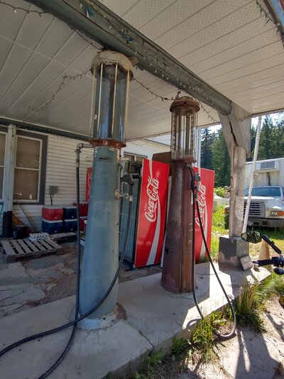
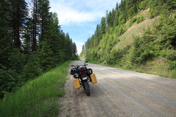
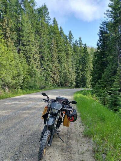
This drive in was in the middle of nowhere. It is open for business.
IMG_20230701_103805169.jpg


IMG_9109.JPG


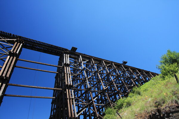
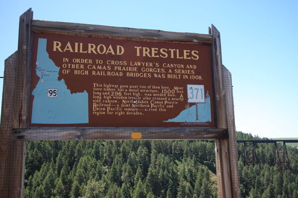
This wooden trestle bridge was built in 1908 and used for 80 years
IMG_9120.JPG


The little platforms built out from the tracks are a puzzle. I asked my donut eating friends and some thought they were for workers, some thought they were for hanging scaffolds used for maintenance and some thought they were for walkers that got caught on the bridge when a train came by. Ideas?
IMG_9121.JPG


IMG_9123.JPG


Metal one built at the same time, only taller and wider.
IMG_20230701_132000865.jpg


If you own a boat repair shop in white water country, you're going to get a lot of non repairable aluminum canoes brought in for repairs. An artistic owner builds an aluminum wave with those left at the shop.
IMG_20230701_142304829.jpg


First year T-bird in WalMart parking lot. Clarkston Washington.
IMG_20230701_185950302_HDR.jpg


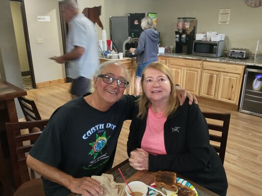
I'm having a memory problem. It seems very selective. I can't look at a map and remember more than one turn I'm supposed to turn on. Once I ride it, most of the time I can remember the last five or six turns and lots of things that I saw along the route. I rode into Clarkston, WA and headed to Walmart. I knew how to get there without having any memory of ever being there, or even being in Clarkston since 2020. After buying some supplies, I used my phone to find a motel and also used it to give me directions. I didn't see anything familiar along the route. When I pulled into the parking lot, I realized I had been there before, but couldn't remember when. When I checked in with the clerk, he asked if I wanted to use the same credit card I used last month. When I got to my room, I checked my log book and I had notes about the motel. Things are getting wierd in my world and I'm having fun with it.
IMG_20230701_190002043_HDR.jpg


Highway 3 in Oregon and Highway 129 in Washington.
IMG_9126.JPG


I met two unusual Harley riders at one of the turnouts along Highway 3. Every year, they go on a two month ride together. Their bikes attest to the fact that they ride dirt roads, even pulling trailers.
IMG_9127.JPG


One quit his job to go on a ride.
IMG_9128.JPG


Both pulled trailers.
IMG_9129.JPG


IMG_9131.JPG


Dispersed camping in some areas require the camper to have a shovel and water if building a campfire. Note chainsaw in the upper right and chainsaw gas in the container.
IMG_9132.JPG


IMG_9133.JPG


IMG_9138.JPG


At one time, there was a single large tree in the bottom of this valley. For years it had been used as a landmark by travelers. Somebody thought it would be a good idea to chop it down in 1843.
IMG_9140.JPG


Painting rocks in the Pacific NW must be a hobby.
IMG_9141.JPG


This monument marks the Oregon trail.
IMG_9142.JPG


I got a motel in Richland, Oregon because I got lost and went down 30 miles of dirt road. All the land was private, so nowhere to camp and it was getting late The next morning I decided to try to ride Highway 73 that had been blocked by snow the month before.

The Oregonians would have lost the battle at Goliad.
IMG_9143.JPG


A couple at a scenic turnout told me I should hike to some alpine lakes. They didn't realize that I could ride the road that they had hiked.
IMG_20230703_121908995_HDR.jpg


My hike was much shorter than their hike.
IMG_9148.JPG


I immediately knew I was in for a treat. Snow in July.
IMG_9151.JPG


Even the trail was pretty.
IMG_9155.JPG


First lake. Worth the hike
IMG_9163.JPG


IMG_9166.JPG


Back on the bike, I continued on a dirt road that was smoother than the road I came in on, but it led to a well used campsite on top of a mountain.
IMG_9170.JPG


IMG_9171.JPG


IMG_9176.JPG


I encountered the same sign I had encountered a month ago, but on the opposite side of the mountain. I decided to ignore this one also. The road was open this time and was a wonderful motorcycle road. Butler maps said gold and I agree. highway 73 west of Baker City, OR.
IMG_20230703_140550999_HDR.jpg


I stopped for a snack and saw this beaver out during daytime.
IMG_20230703_173719754.jpg


Fourth of July parade in small town, America coming up. Also, I started thinking it's time to head back to Texas. The loss of memory about being in Clarkston and Lewiston have me thinking.
 

Attachments

  • IMG_9121.JPG
    IMG_9121.JPG
    343.6 KB · Views: 48
  • IMG_9122.JPG
    IMG_9122.JPG
    331.2 KB · Views: 46
Last edited:
Fourth of July parade in small town, America coming up. Also, I started thinking it's time to head back to Texas. The loss of memory about being in Clarkston and Lewiston have me thinking.


As long as you can't hide your own Easter eggs . . .
 
Back
Top