


-
 Welcome to the Two Wheeled Texans community!
  Feel free to hang out and lurk as long as you like. However, we would like to encourage you to register so that you can join the community and use the numerous features on the site. After registering, don't forget to post up an introduction!
You are using an out of date browser. It may not display this or other websites correctly.
You should upgrade or use an alternative browser.
You should upgrade or use an alternative browser.
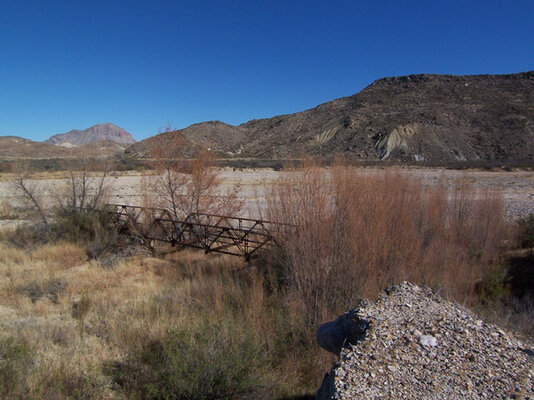
Where is this bridge?
- Thread starter mhutch
- Start date
- Joined
- Feb 28, 2003
- Messages
- 51,257
- Reaction score
- 8,294
- Location
- Huntsville
- First Name
- Scott
- Last Name
- Friday
Gotta be out West if it is in Texas. Where did the pic come from?
Is this a test?
Is this a test?
Chirpy
0
- Joined
- Jan 1, 2004
- Messages
- 6,454
- Reaction score
- 2
- Location
- Hippo town
- First Name
- Daryl
- Last Name
- Tschoepe
I think it's a railroad bridge.
- Joined
- Dec 4, 2005
- Messages
- 622
- Reaction score
- 0
mhutch
0
- Joined
- Apr 6, 2005
- Messages
- 449
- Reaction score
- 1
- Location
- Katy, Tx
- First Name
- Mike
- Last Name
- Hutchinson
Tourmeister said:Gotta be out West if it is in Texas. Where did the pic come from?
Is this a test?
This is a test and Cagiva549 and I took the pic and it is in Texas.
We thought it was railroad at first also but it isn't.
Valker
0
Got one like that up here in the panhandle south of 287 in Palo Duro Canyon (not in the state park part) near the old JA ranch headquarters. Can't remember enough details to know if that is it though.
- Joined
- Mar 6, 2003
- Messages
- 4,676
- Reaction score
- 2
- Location
- Houston
- First Name
- Paul
- Last Name
- Massie
mhutch said:Where o where could it be? Need a road name and a river that it once crossed.
Sounds like a clue there. It appears that there's no deck on the bridge, and it almost looks like it may have shifted off it's original position; perhaps due to a flood. But for me, that just narrows it down to planet Earth.

mhutch
0
- Joined
- Apr 6, 2005
- Messages
- 449
- Reaction score
- 1
- Location
- Katy, Tx
- First Name
- Mike
- Last Name
- Hutchinson
All right. The bridge is on what used to be North County road and is crossing Terlingua creek. The GPS and maps show the road as going through and we took it as far as we could. Dave spotted this bridge on the way back. I would expect that it used to be the main road between Terlingua and Alpine/Marathon back in the day. Here is a map of the area. The private road is now the right fork on the map while heading north and the bridge is at the end of the left most fork. A bit further up, North County road starts to wash out with gulleys and then you come to a locked gate that Dave found when coming the other direction later on (from the north)
ysr612
0
where is this bridge


ysr612
0
Valker said:Looks kind of like the Canadian River bridge in Canadian Texas. Very similar, but I think it is not quite right.
Nice Pics BTW
nope it is on the list of historic bridges in Texas and is 30 years older then the Canadian River bridge. you are right they sure look a lot the same this one is shorter.
and thanks showing off the pictures was the whole idea
Thats the piano bridge at Dubina , It looks good with the new deck . SEYA
ysr612
0
good one I think it is the oldest Iron bridge in Texas. 
DennisD
0
That's close to my area, surprised I've never seen it (Piano bridge that is). What road is it on? I'll have to make a trip there one evening.
ed29
0
- Joined
- Apr 1, 2007
- Messages
- 5,174
- Reaction score
- 17
- Location
- Terlingua Tx
- First Name
- Ed
- Last Name
- Hegarty
I know that road, followed a GPS up there myself one day. The rancher was very cordial when he informed me that I was trespassing on his land, and that the road has been closed for over fifty years. He was very polite, almost friendly even if he was a bit aggravated. I can't figure why Garmin has it on the map since it was closed long before GPS maps were thought up.All right. The bridge is on what used to be North County road and is crossing Terlingua creek. The GPS and maps show the road as going through and we took it as far as we could. Dave spotted this bridge on the way back. I would expect that it used to be the main road between Terlingua and Alpine/Marathon back in the day. Here is a map of the area. The private road is now the right fork on the map while heading north and the bridge is at the end of the left most fork. A bit further up, North County road starts to wash out with gulleys and then you come to a locked gate that Dave found when coming the other direction later on (from the north)
connick
0
K, how about this one?


Scrogg
0
Doh, jumped ahead. I'll wait till the one above gets answered
Last edited:
- Joined
- Dec 4, 2005
- Messages
- 622
- Reaction score
- 0
K, how about this one?
None other than the beautifully redone 1896 Beveridge suspension bridge outside of San Saba.
Tom