Good Morning. We had severe thunderstorms here, but this time much more rain. I haven't looked at my rain gauge yet but feel like 1/4 inch maybe. We are already getting weather alert for potential of severe storms again today on WSMR. Our monsoon almost always kicks off the first of July so maybe this is a good start.


-
 Welcome to the Two Wheeled Texans community!
  Feel free to hang out and lurk as long as you like. However, we would like to encourage you to register so that you can join the community and use the numerous features on the site. After registering, don't forget to post up an introduction!
You are using an out of date browser. It may not display this or other websites correctly.
You should upgrade or use an alternative browser.
You should upgrade or use an alternative browser.
14th Annual Smokey Bear Dual Sport Motorcycle Ride
- Thread starter sanderjavant
- Start date
Simmons1
0
- Joined
- May 29, 2005
- Messages
- 6,026
- Reaction score
- 1,847
- Location
- Out Riding
- First Name
- Rich
- Last Name
- Simmons
Linda and I just booked Cabin 3 at Spruce Cabins for arriving July 24th heading home July 31st.
If the forest is still closed that's fine its still a week out of the heat for us. Probably throw the WR250R on the hitch rack.
If the forest is still closed that's fine its still a week out of the heat for us. Probably throw the WR250R on the hitch rack.
StromXTc
0
I remember last year it hit record rains all over New Mexico.
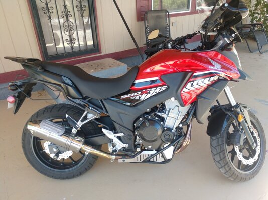
I did a "thing" over the weekend. Picked up a nicely accessorized 2017 CB500x. Had a great time up in Florence Co checking out the Royal Gorge....
Fremont Motorsports had some good people and easy to work with.
Now to figure out do i ride the WR250 or the CB500 that weekend.
I have been working on some routes. Most are easy, about 50/50 dirt and hwy. Im interested to see what others have planned and what they ride and seeing different setups.
Fremont Motorsports had some good people and easy to work with.
Now to figure out do i ride the WR250 or the CB500 that weekend.
I have been working on some routes. Most are easy, about 50/50 dirt and hwy. Im interested to see what others have planned and what they ride and seeing different setups.
Attachments
Last edited:
Simmons1
0
- Joined
- May 29, 2005
- Messages
- 6,026
- Reaction score
- 1,847
- Location
- Out Riding
- First Name
- Rich
- Last Name
- Simmons
I have no planned rides. Not even sure I am bringing a bike yet. If I bring a bike it will be the WR250R and I will still ride easy stuff and blacktop.
If not riding, is there enough "stuff" to do in CC for 5/6 days to keep from being bored? Have only been there once and didn't look like much. Suggestions please.
Simmons1
0
- Joined
- May 29, 2005
- Messages
- 6,026
- Reaction score
- 1,847
- Location
- Out Riding
- First Name
- Rich
- Last Name
- Simmons
If not riding, is there enough "stuff" to do in CC for 5/6 days to keep from being bored? Have only been there once and didn't look like much. Suggestions please.
I have been out there a few times, but Linda has never spent any time there. Here are a few things, none of them take all day but are fun to do:
The Museum of Space History
White Sands National Park
Lincoln County Court House
Smokey Bear Historical Park
Sunspot Observatory
Sitting outside in a lawn chair with a cold beer soaking up 30 degree cooler temperatures than at home.
Thats what i would have said. Its a small community, and Alamogordo isnt that big either. There are rides to be had even if the forest doesnt open. But of course it will be mostly paved rides.
- Joined
- Sep 22, 2006
- Messages
- 2,709
- Reaction score
- 1,967
- Location
- Castroville, Texas
- First Name
- Sander
Come on monsoon season... right now.


We showed .47 inch of rain at my place. And the clouds are building big already today. Maybe monsoon has started early this year
Johnf3
0
One of the folks up on the upper end of Pierce Canyon, which is just down the road from my place is reporting 2 inches so far.
That rain has to be a blessing for many reasons, no doubt many are happy to see it. A friend has a place in Weed and has been very worried about the fire conditions.
AwesomeOne of the folks up on the upper end of Pierce Canyon, which is just down the road from my place is reporting 2 inches so far.
- Joined
- Feb 29, 2016
- Messages
- 1,448
- Reaction score
- 743
- Location
- Austin
- First Name
- Michael
- Last Name
- Morisoli
Hope the fires are assisting the fire crews in their hard efforts all over the state...
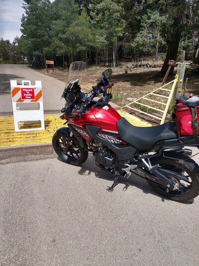
I took a ride up to and around Cloudcroft, pic is from the Suns Spot hwy. I wanted to see how the bike would do and i must say i really enjoyed the new ride. On the way up about Bailey canyon i must have driven through a wet line or something because the temp dropped but at the same time the smell of the pine trees came in strong. I ended up in Sacramento and Weed, thats when the rain hit. And man did it rain, for over two hours, hail, rain lightning and close to me. I got soaked and of course the temp dropped big time. You could definitely tell its been raining up there but not wide spread. Today and tomorrow we are forecast for more showers.
So for some help. Id like to find a riding jacket and pants that have the pads in them. That arent really heavy so i can wear them in the summer so maybe vented yet warm for instances like i dealt with yesterday. And waterproof. Does such a setup exist? I dont want an $900 suit either.
Thanks ....
So for some help. Id like to find a riding jacket and pants that have the pads in them. That arent really heavy so i can wear them in the summer so maybe vented yet warm for instances like i dealt with yesterday. And waterproof. Does such a setup exist? I dont want an $900 suit either.
Thanks ....
Attachments
Sanders, Darn we're booked at Spruce, did they work with you on cancellation charges or do we eat the 50% deposit ? We may go anyway there are many good roads to ride that are not forest service rds ? Please comment.The RIDE is CANCELLED.
Although I do think the forest will be open in time I'm not mother nature, nor a forest manager.
As I know last minute rescheduling and lodging reservations are tough I'm going to pull the plug now.
- Joined
- Sep 22, 2006
- Messages
- 2,709
- Reaction score
- 1,967
- Location
- Castroville, Texas
- First Name
- Sander
I'll be there regardless. I need a break from the heat.Sander, Darn we're booked at Spruce, did they work with you on cancellation charges or do we eat the 50% deposit ? We may go anyway there are many good roads to ride that are not forest service rds ? Please comment.
If the forest is still closed I'll find something else to do instead sweating at home... I'm also on a fly fishing lease near Mayhill that I need to visit, if the fish don't get washed away.
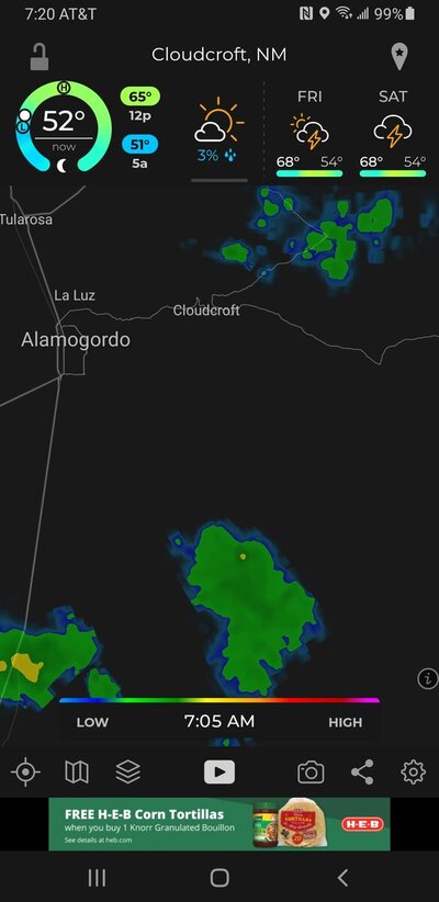
Its been raining there since I woke up this morning - https://www.cloudcroftwebcam.com/
...FLOOD WATCH REMAINS IN EFFECT THROUGH LATE TUESDAY NIGHT... WHAT...Flash flooding caused by excessive rainfall continues to be possible.

Cloudcroft, NM Weather and Radar Map - The Weather Channel | Weather.com
Interactive weather map allows you to pan and zoom to get unmatched weather details in your local neighborhood or half a world away from The Weather Channel and Weather.com
Action Recommended
Avoid the subject event as per the instructionsIssued By
El Paso - TX, US, National Weather ServiceAffected Area
Portions of southern New Mexico, including Otero, Sierra, Dona Ana, Luna, and eastern Grant Counties. Portions of far west Texas, including El Paso and western Hudspeth CountiesDescription
...FLOOD WATCH REMAINS IN EFFECT THROUGH LATE TUESDAY NIGHT... WHAT...Flash flooding caused by excessive rainfall continues to be possible. WHERE...Portions of southern New Mexico, including Otero, Sierra, Dona Ana, Luna, and eastern Grant Counties. Portions of far west Texas, including El Paso and western Hudspeth Counties. WHEN...through 6 AM Wednesday morning. IMPACTS...Areas of steep terrain, urban and low lying areas, and the Black Fire burn scar will be most susceptible to excessive rainfall and rapid runoff. Drainages and arroyos within hilly terrain may cause flooding downstream of heavy rainfall as well. ADDITIONAL DETAILS... - Abundant monsoonal moisture has moved into the region. This moisture will combine with an approaching upper level storm system to develop numerous showers and thunderstorms which could produce heavy rain and excessive runoff. - http://www.weather.gov/safety/flood PRECAUTIONARY/PREPAREDNESS ACTIONS... You should monitor later forecasts and be prepared to take action should Flash Flood Warnings be issued.Yeah it's been raining since last night.
Where is that? Is it a cabin or?Sanders, Darn we're booked at Spruce, did they work with you on cancellation charges or do we eat the 50% deposit ? We may go anyway there are many good roads to ride that are not forest service rds ? Please comment.
The RIDE is CANCELLED.
Although I do think the forest will be open in time I'm not mother nature, nor a forest manager.
As I know last minute rescheduling and lodging reservations are tough I'm going to pull the plug now.
Spruce Cabins in Cloudcroft, graet place to stay.Where is that? Is it a cabin or?
I'll be there regardless. I need a break from the heat.
If the forest is still closed I'll find something else to do instead sweating at home... I'm also on a fly fishing lease near Mayhill that I need to visit, if the fish don't get washed away.
Its been raining there since I woke up this morning - https://www.cloudcroftwebcam.com/
...FLOOD WATCH REMAINS IN EFFECT THROUGH LATE TUESDAY NIGHT... WHAT...Flash flooding caused by excessive rainfall continues to be possible.
Cloudcroft, NM Weather and Radar Map - The Weather Channel | Weather.com
Interactive weather map allows you to pan and zoom to get unmatched weather details in your local neighborhood or half a world away from The Weather Channel and Weather.comweather.com

Action Recommended
Avoid the subject event as per the instructions
Issued By
El Paso - TX, US, National Weather Service
Affected Area
Portions of southern New Mexico, including Otero, Sierra, Dona Ana, Luna, and eastern Grant Counties. Portions of far west Texas, including El Paso and western Hudspeth Counties
Description
...FLOOD WATCH REMAINS IN EFFECT THROUGH LATE TUESDAY NIGHT... WHAT...Flash flooding caused by excessive rainfall continues to be possible. WHERE...Portions of southern New Mexico, including Otero, Sierra, Dona Ana, Luna, and eastern Grant Counties. Portions of far west Texas, including El Paso and western Hudspeth Counties. WHEN...through 6 AM Wednesday morning. IMPACTS...Areas of steep terrain, urban and low lying areas, and the Black Fire burn scar will be most susceptible to excessive rainfall and rapid runoff. Drainages and arroyos within hilly terrain may cause flooding downstream of heavy rainfall as well. ADDITIONAL DETAILS... - Abundant monsoonal moisture has moved into the region. This moisture will combine with an approaching upper level storm system to develop numerous showers and thunderstorms which could produce heavy rain and excessive runoff. - http://www.weather.gov/safety/flood PRECAUTIONARY/PREPAREDNESS ACTIONS... You should monitor later forecasts and be prepared to take action should Flash Flood Warnings be issued.
I'm going as well. I'll find some roads to ride. Will be needing a break from the heat as well. Let's hope they open the forest by then, I'm betting they will.
jwaller
0
- Joined
- May 2, 2012
- Messages
- 361
- Reaction score
- 277
- Location
- Cibolo, TX
- First Name
- Justin
- Last Name
- Waller
My wife and I will most likely be somewhere around Cloudcroft this year, whether I can ride a motorcycle or not. We really enjoyed our stay at the Cloud Climbing Railroad Campground last year. Also, anything to get out of this heat.
You guys keep me posted. I am taking a few days off to go ride that week and had plans to meet up with your group for that weekend.