• Welcome to the Two Wheeled Texans community! Feel free to hang out and lurk as long as you like. However, we would like to encourage you to register so that you can join the community and use the numerous features on the site. After registering, don't forget to post up an introduction!

The "Non-Invasive" Dirt Roads Around Austin Thread

Hey Coolhand,

In our exploration today, I learned which roads are NOT dirt roads but were still fun to ride on. :pirate:

I was thinking for our map that we could use red icons for paved roads and blue for dirt. This way as we get more roads identified, we'll know which roads we've explored but learned they were not dirt.

Thoughts? :ponder:
 
Make it so, Number 1.

(not that I'm Picard, in fact, I always thought Picard was kind of a wuss...)
 
I made it home no problem. Feet were soaked, I'm lucky it wasn't really cold. Santa is getting a last minute memo about new handlebars and shifter today.

For anyone reading this, the Click Road area is really fun right now but there are some spots you REALLY need to pay attention to!
 
Dec 22nd Ride Report - Reconnaissance Mission #1

So I went on a little reconnaissance trip with John/jthompson and Justin/je2000 to try and map out more dirt roads. I just updated the Google map with paved, dirt and points of interest. Had a great ride of around 355 miles.

Here are some pics I added to the Google Map.
CR307 off of Hwy 281
2009DEC22_Motorcycle002.jpg


Threadgill Creek Rd - (also marked as Squaw Creek) - 3 water crossings
2009DEC22_Motorcycle016.jpg
2009DEC22_Motorcycle017-1.jpg
2009DEC22_Motorcycle020.jpg

2009DEC22_Motorcycle022.jpg
2009DEC22_Motorcycle023.jpg


Salt Branch Loop, Onion Creek Rd and E. Mill Road Intersection
2009DEC22_Motorcycle027.jpg


More Salt Branch Loop
2009DEC22_Motorcycle034.jpg
2009DEC22_Motorcycle036.jpg


We made it all the way up to Mason and then headed back to Austin along Simonsville Rd which is a nice long dirt road. Went through Loyal Valley along House Mt Rd and on through the Click area along 315 and 310.

Justin was reminded that even though some water crossing are short and shallow, they still can be extremely slick!! :lol2:
2009DEC22_Motorcycle046.jpg

2009DEC22_Motorcycle047.jpg


Ouch!! Bent Shifter!! :doh:
2009DEC22_Motorcycle045.jpg


We got her fixed and all made it home safe and sound. Great ride gents!! :clap:
 
:clap:

Wow lots of water out there compared to the last time I was in that area.

Have a good Christmas folks, we're outta here.

J
 
Glad to see you all are finding some nice riding around Austin. I can't wait to hit these roads! Great report.
 
Hey Coolhand,

In our exploration today, I learned which roads are NOT dirt roads but were still fun to ride on. :pirate:

I was thinking for our map that we could use red icons for paved roads and blue for dirt. This way as we get more roads identified, we'll know which roads we've explored but learned they were not dirt.

Thoughts? :ponder:

Hi tj,
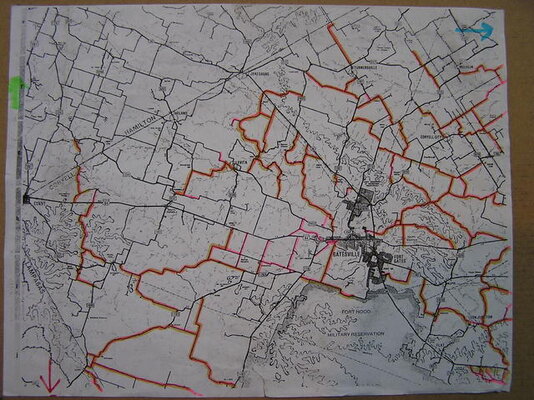
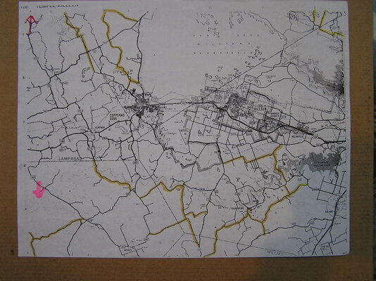
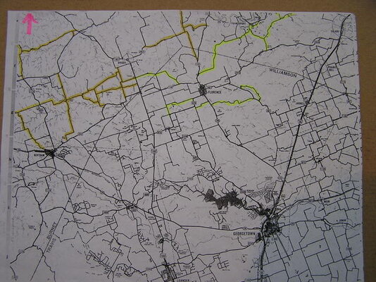
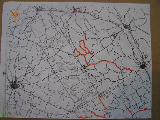
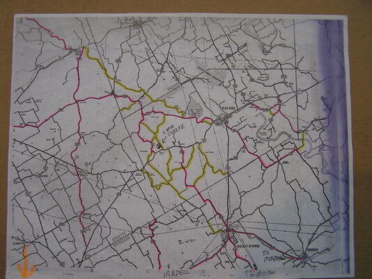
I've been trying to post copies of these maps I made from Roads o Tx on ADV & TWT but have been unable to scan them due to scanner problems.I took pics of them instead & will post here since they might give some useful info for this thread. Let me say right up front....THESE ARE ALL PAVED COUNTY ROADS....but most of them are entertaining to ride nontheless.Still many more to get highlighted but you can get an idea of the stuff up north.I can email larger copies of pics to those interested.
We're gonna be riding some of them (along with gravel rds) on New Year's Day from 12-4PM.
 

Attachments

  • County Rd Map Pics 011.jpg
    County Rd Map Pics 011.jpg
    81.9 KB · Views: 346
  • County Rd Map Pics 004.jpg
    County Rd Map Pics 004.jpg
    61.2 KB · Views: 303
  • County Rd Map Pics 007.jpg
    County Rd Map Pics 007.jpg
    77 KB · Views: 289
  • County Rd Map Pics 008.jpg
    County Rd Map Pics 008.jpg
    67.4 KB · Views: 301
  • County Rd Map Pics 009.jpg
    County Rd Map Pics 009.jpg
    68.1 KB · Views: 278
I've been trying to post copies of these maps ....THESE ARE ALL PAVED COUNTY ROADS....but most of them are entertaining to ride nonetheless.
Hey Rod, Thanks for the info!! :thumb:
If you wanted to get added as a collaborator on the Google map so you can also add that info there, send me a PM with your email address and I'll add you. :clap:
 
Man, am I a moron. My HTML skills are getting soft. I need to get them up to speed again. :doh:

You don't have to re-size pics to have them come out sized nicely on the Google map.
There is a little utility that will help with that. I put together a quick little tutorial for how to do it and made it into an image so you can see all of it.

GoogleMapEditing_Image.jpg


Personally, I like sizing the pics to 350, so you can change the style="width:242px" to style="width:350px"
 
These first two are on Old Sayers Rd./CR49. Winding dirt/gravel/ground up asphalt/pavement with lots of dips and dives.
aa1.jpg

aa2.jpg


These are Gotier Trace road going East away from the park.
aa3.jpg

aa4.jpg


From Gotier Trace I turned right on CR154 then turned right again on Park Road 1-C. This picture is on Park Road 1-C.
aa5.jpg
 
Hey rlcanon,

Thanks for posting the pics. :clap:
I've added them to the map. 2 of the roads Coolhand already had marked so I just added additional pics.

Thanks! I'm the epitome of that annoying combination of technically incompetent and lazy that Okies are known for. They're also know for bestiality, but I don't know anything about that personally. :lol2:

anyone doing any exploring :trust: this week?

When and where were you thinking?
 
Im down for going either west or east. Maybe wed or friday, thurs if we cut it short for the game (airs at 7:30?), then again i could skip it for a good ride. Im flexible.... just have the itch.
 
Thanks! I'm the epitome of that annoying combination of technically incompetent and lazy that Okies are known for. They're also know for bestiality, but I don't know anything about that personally. :lol2
Just FYI, wherever you are hosting the pics, I didn't copy them to another storage area. Meaning if you delete them from where you are hosting, they will be removed from the Google maps and it will look like a broken link.
Thanks for contributing. :thumb:
 
rlcanon, looking at the map, it seems like there is more posting to be done on the east side.
 
If you guys find anything good on the east side in addition to those posted by rlcanon I'd like to see 'em. I still need to get towards Gonzales and scout that area, and the Waco guys seem to find quite a bit of decent stuff their way as well...
 
Let me know when you go to Gonzales. I can only go after 12 and wed seems to be the best day weather wise. It would have to be short, slab it east and head back west.
 
Not enough time to explore tomorrow... Im gonna try and chase power lines. Ive been looking at google maps and the "non invasive" aspect makes the dirt more difficult to find. Besides, development may have occurred since the pictures were taken.
 
I'm using the Mac version of Firefox v3.5.6 and no crashes for me.
 
I got some gents over at ADV Rider starting to contribute. They've add a bunch of info.

I had been working on getting my paper highlighted county road maps posted for quite a while but kept having various computer related problems doing that.Contributing my paved road collection to this Google map (+ some gravel stuff too) seems like the way to go in getting the info "out there" for other riders to use & enjoy.
Myself & other riders in the area further north are expanding the original scope of the map northward but I hope that the extra exceptional roads will help link the southern areas around Austin/San Antone to the Killeen/Temple/Waco area & beyond to the DFW metromess.
NO ONE SHOULD HAVE TO RIDE FROM DALLAS TO SAN ANTONIO ON I35. There are too many nice county roads to enjoy.

Still workin on getting pics posted to some of our road markers.
 
Back
Top