Sooo happy to see you enjoying our lil' state Gina!


-
 Welcome to the Two Wheeled Texans community!
  Feel free to hang out and lurk as long as you like. However, we would like to encourage you to register so that you can join the community and use the numerous features on the site. After registering, don't forget to post up an introduction!
You are using an out of date browser. It may not display this or other websites correctly.
You should upgrade or use an alternative browser.
You should upgrade or use an alternative browser.
New Mexico, Again!
- Thread starter SpiritAtBay
- Start date
New Mexico sure has some pretty sunsets and the petroglyphs are super cool. Thanks!
Sooo happy to see you enjoying our lil' state Gina!
Hey Chris!
We do like this crazy state quite a bit. Although when the speed limit goes from 55 to 45 to 35 then ratchets back up to 55 all within 2 miles of unchanging road conditions/environment, we then call it the Land of Confusion lol
Thanks for dropping in!
I agree with the unhappy hiker about walking to see thos petroglyphs. I think they're like football, better observed from your recliner on the big screen. 
TNC
0
Sounds like the speed trap at Cuba, NM. Got one of my buddies even after I warned him.Hey Chris!
We do like this crazy state quite a bit. Although when the speed limit goes from 55 to 45 to 35 then ratchets back up to 55 all within 2 miles of unchanging road conditions/environment, we then call it the Land of Confusion lol
Thanks for dropping in!
TNC
0
SpiritAtBay, those pics of riding in the wash to Crow Canyon looks so much like riding the wash in Fresno Canyon in the Big Bend Ranch State Park...cottonwoods, bluffs, loose soil...beautiful.
Soon after crossing into NM, John removed the front plate off the pickup. Without that plate, we get friendly waves in small towns.Sounds like the speed trap at Cuba, NM. Got one of my buddies even after I warned him.
The day after exploring Crow Canyon, we packed up camp and left Farmington. It was threatening rain, the first we’ve seen this trip. We washed clothes at what must be the world’s cleanest laundromat. Woman working there wiped and cleaned machines, floors, tables, chairs, everything the whole time we were there. They even had dedicated machines for oilfield workers.
We were headed to Canyon de Chelly but the rained dogged us all day. Even so, it was a gorgeous drive thru the Chuska mtns.

Check the downhill grade

We are a little late to see fall colors.

On the west side of the mountains we were surprised to see these huge red rock formations.


Park ranger at Canyon de Chelly told me the whole area is called Red Valley.
There were many Navajo communities, each like a small neighborhood. We also noticed many round or octagonal structures. When we got internet again, I learned these are called Hogan and are a modern interpretation of traditional Navajo homes.
At Canyon de Chelly, we started driving the south rim but it was raining hard and visibility was low so we left. We headed for our next habitation, an rv park kinda in the middle of nowhere, west of Grants. But close to El Morro Natl Monument and our next adventure destination, the “Big Tubes“ in El Malpais Natl Conservation Area.
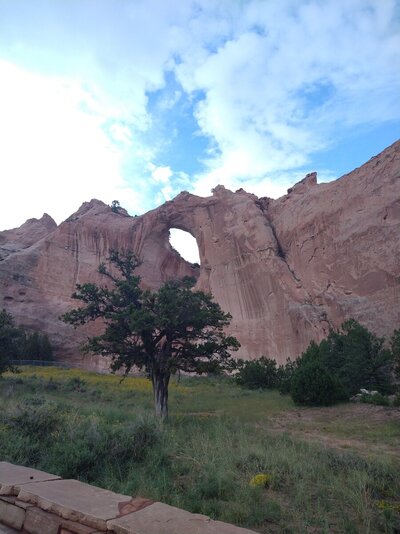
Along the way, we stopped at Window Rock. Window Rock is a formation, a town and a war memorial.
The "window" is huge. Photos just don't convey...


Neither does John convey the seriousness of Public Health Order 2020-14


Coins were scattered over the bricks bearing the names of locals who died serving their country. Some of the coins appeared to be commemorative.
After leaving Window Rock, I noticed I didn't have internet or cell service. We arrived in Gallup, needing to fill up and found we had to pay cash because the internet was down all over town. We had no cell or internet for the rest of the day. That was a strange feeling!

We arrived right before dusk and had just enough light to set up camp. Thankfully it stopped raining long enough for us to do so.
We had driven over 300 miles, almost all of it in rain.
We were headed to Canyon de Chelly but the rained dogged us all day. Even so, it was a gorgeous drive thru the Chuska mtns.
Check the downhill grade
We are a little late to see fall colors.
On the west side of the mountains we were surprised to see these huge red rock formations.
Park ranger at Canyon de Chelly told me the whole area is called Red Valley.
There were many Navajo communities, each like a small neighborhood. We also noticed many round or octagonal structures. When we got internet again, I learned these are called Hogan and are a modern interpretation of traditional Navajo homes.
At Canyon de Chelly, we started driving the south rim but it was raining hard and visibility was low so we left. We headed for our next habitation, an rv park kinda in the middle of nowhere, west of Grants. But close to El Morro Natl Monument and our next adventure destination, the “Big Tubes“ in El Malpais Natl Conservation Area.
Along the way, we stopped at Window Rock. Window Rock is a formation, a town and a war memorial.
The "window" is huge. Photos just don't convey...
Neither does John convey the seriousness of Public Health Order 2020-14
Coins were scattered over the bricks bearing the names of locals who died serving their country. Some of the coins appeared to be commemorative.
After leaving Window Rock, I noticed I didn't have internet or cell service. We arrived in Gallup, needing to fill up and found we had to pay cash because the internet was down all over town. We had no cell or internet for the rest of the day. That was a strange feeling!
We arrived right before dusk and had just enough light to set up camp. Thankfully it stopped raining long enough for us to do so.
We had driven over 300 miles, almost all of it in rain.
Attachments
Last edited:
TheD-Man
0
Great write up.
I feel like you meant there to be embedded pictures included?
I feel like you meant there to be embedded pictures included?
Great write up.
I feel like you meant there to be embedded pictures included?
Ya. I write the text on ipad, post it, then go back and insert pix from cellphone. Rather laborious but I hate dealing with photo hosting sites.
Morning dawned very wet and chilly, but not raining. We had an excellent breakfast at the on-site cafe. Asked if we could leave the truck and trailer for a few hours (no problem), mounted up and headed for Big Tubes. BT is a series of large lava tubes, some with “windows” - collapsed portions of tube that let sunlight in. Directions were sketchy at best and we hoped for signage to help us find the trailhead. About the only thing the Natl Park Service seems to want you to know is that the track getting to the trailhead is impassable when wet. Clearly, they are tired of getting vehicles unstuck.
On the way, we got distracted by these candyland colored spires. We followed a little road that led toward them and snapped some pix.


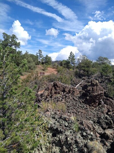
Due to John’s mad gps skillz, and not due to signage (there was none), we found the turn off for Big Tubes and enjoyed riding the mild sandy track that ran beside a lava field with burned, stunted trees. We both agreed this track could easily turn into a real quagmire.


***trailhead***
Reaching the trailhead, we geared up for a hike through sharp, uneven lava rocks. The trail was narrow and faint but there were cairns marking the path. We hadn’t gotten far at all though when a rogue cloud parked itself overhead and threw a few big drops at us. John hadn’t been too keen on the whole idea anyway and Gina was definitely not keen on riding that road when wet. So, we beat a hasty retreat to the bikes.
The ride back out was dry and fun, except for a yahoo in a big pickup barreling round a sharp curve completely on the wrong side of the road, forcing me into the berm and offering him a one fingered salute.
Hitting pavement and with blue skies overhead, we decided to visit the Bandera Crater and Ice Cave. A private enterprise, the same family has been operating this natural wonder for generations. Well worth the $12 admission. We took the scenic trail, rather than a shorter, more straightforward path, first visiting the ice cave.
A short walk to these steps

The ambient temp drops as you descend the steps. The wooden handrails are real cold.
The temp in the cave never rises above 31*. You can just make out a vertical wall of ice at the back, right hand side. The green pool is a thin layer of water over ice that is 20' thick.

It was too cold to stay down there for long. (Plus, the idea of the thing is greater than the reality of it, imo.) Still glad we went.
We continued toward the cinder cone crater. Points of interest are marked along the trail and were indeed interesting and pointed out things I would have missed.
There was no POI for this apricot colored velvet ant.


The arched dome is the remains of a lava tube


Just as we reached the crater, a dark, threatening cloud lunged into view and seemed to have set it’s sights on us. We hotfooted it back to the bikes and made a fast dash back to camp, 15 miles away. We got caught in the rain and arrived soaked and cold. We were also hungry. There was just enough time to eat at the cafe and let the rain pass by. Then we loaded up and headed for our next stop, Mimbres Valley, 130 miles away.


On the way, we got distracted by these candyland colored spires. We followed a little road that led toward them and snapped some pix.
Due to John’s mad gps skillz, and not due to signage (there was none), we found the turn off for Big Tubes and enjoyed riding the mild sandy track that ran beside a lava field with burned, stunted trees. We both agreed this track could easily turn into a real quagmire.
***trailhead***
Reaching the trailhead, we geared up for a hike through sharp, uneven lava rocks. The trail was narrow and faint but there were cairns marking the path. We hadn’t gotten far at all though when a rogue cloud parked itself overhead and threw a few big drops at us. John hadn’t been too keen on the whole idea anyway and Gina was definitely not keen on riding that road when wet. So, we beat a hasty retreat to the bikes.
The ride back out was dry and fun, except for a yahoo in a big pickup barreling round a sharp curve completely on the wrong side of the road, forcing me into the berm and offering him a one fingered salute.
Hitting pavement and with blue skies overhead, we decided to visit the Bandera Crater and Ice Cave. A private enterprise, the same family has been operating this natural wonder for generations. Well worth the $12 admission. We took the scenic trail, rather than a shorter, more straightforward path, first visiting the ice cave.
A short walk to these steps
The ambient temp drops as you descend the steps. The wooden handrails are real cold.
The temp in the cave never rises above 31*. You can just make out a vertical wall of ice at the back, right hand side. The green pool is a thin layer of water over ice that is 20' thick.
It was too cold to stay down there for long. (Plus, the idea of the thing is greater than the reality of it, imo.) Still glad we went.
We continued toward the cinder cone crater. Points of interest are marked along the trail and were indeed interesting and pointed out things I would have missed.
There was no POI for this apricot colored velvet ant.
The arched dome is the remains of a lava tube
Just as we reached the crater, a dark, threatening cloud lunged into view and seemed to have set it’s sights on us. We hotfooted it back to the bikes and made a fast dash back to camp, 15 miles away. We got caught in the rain and arrived soaked and cold. We were also hungry. There was just enough time to eat at the cafe and let the rain pass by. Then we loaded up and headed for our next stop, Mimbres Valley, 130 miles away.
Attachments
Last edited:
The photos of the various landscapes are drop dead gorgeous. You could turn them into calendars and sell them for 2023! And it is good to see that JT is obeying the letter of the law! LOL
The photos of the various landscapes are drop dead gorgeous. You could turn them into calendars and sell them for 2023! And it is good to see that JT is obeying the letter of the law! LOL
Thanks, Rex. The lands of NM can make anyone look like they have skill!
Have more pix to add but it's time to pick up camp and move on.
Later amigos!
Dahveed
0
Great RR! Keep the updates coming and ride safe. I'm at home wondering why I'm not somewhere riding...
TNC
0
Love that area down 117 in your pics. That Joe Skeen free BLM campground by the Malpais on 117 is a good, no amenities camping area. Camping on the bluff/highway side overlooks the Malpais and some great scenery.
I did that whole area south of I-40 to 117 and west to 36 not long ago and was surprised how much dirt road and 2-track riding was in there...hardly anyone around.
I did that whole area south of I-40 to 117 and west to 36 not long ago and was surprised how much dirt road and 2-track riding was in there...hardly anyone around.
Love that area down 117 in your pics. That Joe Skeen free BLM campground by the Malpais on 117 is a good, no amenities camping area. Camping on the bluff/highway side overlooks the Malpais and some great scenery.
I did that whole area south of I-40 to 117 and west to 36 not long ago and was surprised how much dirt road and 2-track riding was in there...hardly anyone around.
that’s some good info. Did you use a MVUM from the forest service?
TNC
0
Oddly, I usually rely on Google Maps & Sat views for planning and post ride. On the trail I use DeLorme Gazetteer pages pulled out of the book. I do carry a Garmin handheld GPS for real time positioning, but I've never used tracks or such. I'm pretty old school as I like maps. I probably differ greatly from the methods used by most.that’s some good info. Did you use a MVUM from the forest service?
I've found that my weird method doesn't keep me nailed down to a specific course, though I'm not saying I don't have a general plan when hitting backroads, 2-tracks, or singletrack. I have stumbled on to some amazing places and sights doing it this way.
I have a big gas tank.
- Joined
- Oct 16, 2008
- Messages
- 3,785
- Reaction score
- 4,877
- Location
- Bryan, TX
- First Name
- Dennie
- Last Name
- Spears
"There were many Navajo communities, each like a small neighborhood. We also noticed many round or octagonal structures. When we got internet again, I learned these are called Hogan and are a modern interpretation of traditional Navajo homes."
In my opinion, the hogans are one of the reasons that the Navaho have suffered such devastating losses to Covid. They continued to use them for religious purposes during covid, despite the close quarters and near complete lack of ventilation.
In my opinion, the hogans are one of the reasons that the Navaho have suffered such devastating losses to Covid. They continued to use them for religious purposes during covid, despite the close quarters and near complete lack of ventilation.
- Joined
- Nov 25, 2012
- Messages
- 18,504
- Reaction score
- 679
- Location
- Lampasas
- First Name
- Drew
- Last Name
- Wright
Lovely pics. Just lovely.
That is heartbreaking"There were many Navajo communities, each like a small neighborhood. We also noticed many round or octagonal structures. When we got internet again, I learned these are called Hogan and are a modern interpretation of traditional Navajo homes."
In my opinion, the hogans are one of the reasons that the Navaho have suffered such devastating losses to Covid. They continued to use them for religious purposes during covid, despite the close quarters and near complete lack of ventilation.
Were the lava tubes open? When I was there in April there was a small "closed to all visitors" sign. Nice pics.
Thanks, Dennie.
Where was that sign, I wonder?
Verbiage on official website was unclear. I think one of the visitor centers was listed as closed. Big Skylight was listed as closed, but the other tubes were not mentioned. Because we were coming from the west, the visitor center was out of the way so we didn't "visit" it.
As I mentioned, the turnoff the highway had no signage for Big Tubes. Once on the road, there were multiple signs warning that the road becomes impassable when wet. (There were pix of stranded vehicles on the website.). But nothing saying the trail or tubes were closed.
After about 3 miles on the dirt road, there was a sign for Big Tubes to the left. (I'll add a pic of that sign.)
At the trailhead, there was some signage saying to wear a mask in the caves. There also was a decontamination station with boot scrapers and a vat of hydrogen peroxide to dip the soles of your boots in. I think that may be an effort to mitigate white nose disease (and\or other diseases.)
Thanks again.
- Joined
- Oct 16, 2008
- Messages
- 3,785
- Reaction score
- 4,877
- Location
- Bryan, TX
- First Name
- Dennie
- Last Name
- Spears
One of the signs of warning. It's my understanding that the signs are routinely ignored, hence the "Cibola County will not be liable if you decide to ignore this sign.

I came in from the east side of the park and there was no sign about the lava tubes until I reached the T heading to the tubes. I actually was becoming a little anxious, thinking I had taken a wrong turn, because the turn off from the east was more than 15 miles from the paved road.
The closed sign was right at the trailhead.
Last edited:
- Joined
- Oct 16, 2008
- Messages
- 3,785
- Reaction score
- 4,877
- Location
- Bryan, TX
- First Name
- Dennie
- Last Name
- Spears
It's been 9 days since my wife and I returned from a 15 day trip to California. Your pictures and those of Jeephoto have convinced me I need to return to New Mexico and slow down my pace. I hope you don't mind, but I would like to steal your route and agenda after I have done the same to Jeephoto. It cuts down on planning time. I leave on Friday.